Freimann
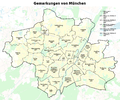
Free man is a Munich area and forms, together with the eastern part of Schwabing the municipality 12 - Schwabing-free man .
Freimann clearly stands out from the classic Munich self-image and in particular from that of the sister city district Schwabing in the shared city district with its intensive breakdown by traffic and industrial infrastructure.

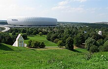
In Freimann there is a combination of old cultivated land, the oldest chapels and churches of the city area ( St. Nikolaus ), the Gutshof Großlappen with sewage treatment plant and former mountains of rubbish Fröttmaninger Berg and landfill north-west , the wind power plant Fröttmaning , the Allianz Arena , Showpalast Munich , MOC trade fair , mosque , media (studios of the Bavarian Broadcasting Corporation , headquarters of the Institute for Broadcasting Technology and 102-meter-high radio tower built in 1954 for broadcasting programs to the broadcasting locations), but also allotments, shopping centers, new and old parts of the city ( pine garden ), culture and celebrities in the Surroundings of Blumenring, St. George's - The British International School Munich , the Zenith , the Motorworld Munich , the Mohr-Villa and the Metropoltheater . A place for subculture is being planned on the previously unused open space around the Freimann high bridge .
location
Freimann comprises several districts, Schwabing joins in the south, with which it forms the district 12 - Schwabing-Freimann. The Nordring railway line acts as a border . Only two small sections south of the tracks of the Nordring still belong to Freimann: One of them is west of the tram tracks of Tram 23 and north of Domagkstraße and the second is east of Ungererstraße and north of Crailsheimstraße and west of Rohmederstraße. In the west, Leopoldstrasse and later Ingolstädter Strasse , for example, form the border to district 11 - Milbertshofen-Am Hart , for example the Kaltherberge settlement east of Ingolstädter Strasse does not belong to Freimann. In the east, the district ends on the Isar . In the north, Freimann extends to the municipality boundary of Oberschleißheim and the city boundary of Garching .
Education and culture
- Zenith event hall
- St. Nikolaus , Heinrich-Groh-Straße 11
- St. Catherine of Siena , horse lane 2A.
- Hope Church , Carl-Orff-Bogen 217
- Freimann cultural center in the Mohr Villa built in 1870 on Situlistraße. Among other things, rain shelter and a permanent venue for the autumn season of the Munich summer theater .
- Metropol-Theater , Floriansmühlstrasse
- Freimann branch of the Munich Adult Education Center , Keilberthstrasse 6, 2nd floor
- Youth center LOK Freimann
- Montessori Technical College Munich, Langfeldstrasse 6
- St. George's - The British International School Munich , Heidemannstrasse 182
history
Freimann, the eponymous part of the city district, was first mentioned in a document in 948 and 957 as ad Frienmannun .
The old village and first parish church of Freimann was mentioned as early as 1039. Originally dedicated to St. Margaretha, the patronage was changed to St. Nicholas in 1739. Together with the parcels around today's Hans-Groh-Straße, this represents the historic center of the village. For centuries, it comprised only a few courtyards. As a rule, the peasants had a landlord to whom they owed interest. In Freimann these were often church institutions, such as the cathedral capital Freising and the monasteries Weihenstephan, Tegernsee and Andechs. But citizens of Munich also acted as landlords, with only one farm being the owner of the property.
In 1500 fourteen properties are mentioned, four of which are large courtyards. Even in 1760 there are only thirteen properties. The fact that Freimann did not grow during this time is due to its location in the Munich gravel plain, the areas of which are not very fertile. In addition, the eastern areas of the village are regularly flooded by the Isar, so at least the farmers in these areas have suitable pasture opportunities for their cattle.
In 1808, as part of the Bavarian administrative reform, the (tax) community Freimann was founded, together with the community Milbertshofen it formed the Freimann tax district in the Landsberg district court. The districts Kultursheim (today Kulturheim ), Lappen (see Klein - & Großlappen ), Neufreimann , which was just emerging at the time, and the village of Fröttmaning also belonged to the community .
Due to the community reform, community committees had to be elected to ensure public peace, security and order. Among other things, they also had to agree to marriages and participated in the school and building supervision. Mathias Herrmann was the first mayor of Freimann from 1834 to 1835. The Reischlweg in Munich is named after the last mayor before it was incorporated into Munich (Anton Reischl). Josef Raps, who was responsible for Dr. Peter Schloderer took over the post of mayor on behalf of a street in Munich.
1927 next to the newly built was Reichsbahn - Ausbesserungswerk Freimann built a large housing estate for the workers of the factory, in 1932 the building was made of a so-called Empire Standard settlement between the Freisinger Landstrasse and the Schleißheimer channel.
Freimann and its districts were incorporated into Munich on October 1, 1931. In 1936 the construction of today's Bayern barracks began . When the district committees were brought into being after the end of the Second World War in 1947, Freimann was merged with Schwabing . With a resolution of February 2, 1954, the city council finally determined the name of the newly created district as Schwabing-Freimann .
After the end of the Second World War, Munich belonged to the American zone of occupation . The American military administration set up the Neu-Freimann DP camp in Freimann to accommodate so-called displaced persons (DP). For this purpose, part of the Kaltherberg workers' settlement was confiscated. The camp housed over 2,500 DPs and was looked after by a team from UNRRA . After conflicts with the other residents of the settlement, the camp was closed in June 1949 and the site was returned to the settlers. The DPs were allocated living space on Ingolstädter Strasse. In addition to the Neu-Freimann camp, there was a transit camp for DPs in the former radio barracks . In the north is the Fürst-Wrede barracks . The new FC Bayern performance center is to be built here on an area of 30 hectares .
North of Heidemannstrasse , two settlements were built from 1948 on parts of what was then the military training area ( Kieferngarten ), in which, in particular, displaced persons from the former German eastern regions received new living space.
To the west of the old town center, on Lilienthalallee , is the MOC event center planned by US architect Helmut Jahn and operated by Messe München GmbH.
While there was no ski operation in winter 2017/2018 and winter 2018/2019, the construction of a new four-seater chairlift and the resumption of skiing on Fröttmaninger Berg may be planned for winter 2019/2020 .
Architectural monuments
List of architectural monuments in Munich / Freimann
nature
traffic
Freimann has good traffic connections: In the south, the Mittlerer Ring runs from west to east, Bundesstraße 11 crosses the eastern part of Freimann as Ungererstraße , Situlistraße and at the height of Heidemannstraße as Freisinger Landstraße in a north-south direction. The federal motorway 9 ( Munich - Berlin ) runs parallel to the B 11 and opens up Freimann with the junctions Munich – Frankfurter Ring , Munich – Freimann and Munich – Fröttmaning-Süd .
Freimann is connected to the MVV network by the U6 underground line with the Studentenstadt , Freimann , Kieferngarten and Fröttmaning stations . The technical base of the Munich subway is also located in Fröttmaning .
literature
- Brigitte Fingerle-Trischler: Freimann in the north of Munich. Volk Verlag, Munich 2018, ISBN 978-3-86222-274-2 .
- Marion Maurer: Freimann - a community in the shadow of the big city. Buchendorfer Verlag, Munich 1985.
Web links
- Mohr-Villa homepage
- District page on Freimann-Fröttmaning
- Culture and History Trail Schwabing-Freimann (PDF) City of Munich
Individual evidence
- ↑ https://www.sueddeutsche.de/muenchen/muenchen-freimann-a9-projekt-subkultur-1.4743291
- ^ Wilhelm Volkert (ed.): Handbook of Bavarian offices, communities and courts 1799–1980 . CH Beck, Munich 1983, ISBN 3-406-09669-7 , p. 601 .
- ↑ In Ingolstädter Straße: New FC Bayern performance center in 2017 . Abendzeitung-muenchen.de. May 21, 2015. Accessed October 31, 2015.
- ↑ Philipp Schneider: Performance Center of FC Bayern: Aufgemortelt for Europe . In: Süddeutsche Zeitung , October 17, 2015. Accessed October 31, 2015.
- ↑ skiresort.de
Coordinates: 48 ° 12 ' N , 11 ° 36' E


