
Freisinger Landstrasse
| Freisinger Landstrasse | |
|---|---|
|
|
|
 |
|
| Beginning of the Freisinger Landstrasse | |
| Basic data | |
| State capital | Munich |
| Borough | Schwabing-Freimann |
| Name received | 1950 |
| Connecting roads | Rosmarinstraße, Floriansmühlstraße, Emmerigweg, Heidemannstraße , Josef-Wirth-Weg, Wallnerstraße, Lottlisa-Behling-Weg, A 99 , Wagrainweg |
| Cross streets | Situlistraße, Staatsstraße 2350 |
| Numbering system | Orientation numbering |
| use | |
| User groups | Pedestrian traffic , bicycle traffic , individual traffic , public transport |
| Technical specifications | |
| Street length | 4.1 km |
The Freisinger Landstrasse is a 4.1 km long inner-city road in the Freimann district of Munich . It leads - initially in an arc - from Situlistraße (as an extension of Ungererstraße ) further north to the city limits. It crosses under the A 99 at the Munich-North interchange . It is named after the city of Freising , where it leads as State Road 2350 . It was part of the B 11 until it was downgraded in 2015 .
The Fröttmaninger Berg , the Islamic Center Munich with the Freimann Mosque , the Obere Isarau , the Schleissheim Canal , the NO 60 allotment garden , the floodplain settlement and the Gut Großlappen sewage treatment plant are located on it . In the east the Garching Mühlbach and the Isar run parallel to the street .

Fröttmaninger Berg

Freimann mosque

Meadow settlement
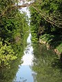
Schleissheim Canal

Gut Grosslappen sewage treatment plant


Coordinates: 48 ° 11 ′ 43.2 " N , 11 ° 37 ′ 26.7" E
Individual evidence
- ^ Hans Dollinger: The Munich street names. 7th edition. Südwest-Verlag, Munich, 2007, ISBN 978-3-517-08370-4
- ↑ Bavarian State Gazette . No. 36 , 2015.