
Ungererstrasse
| Ungererstrasse | |
|---|---|
|
|
|
 |
|
| Corner house Ungererstraße 32 | |
| Basic data | |
| State capital | Munich |
| Borough | Schwabing-Freimann |
| Hist. Names | Landshuter Strasse, Freisinger Landstrasse (until 1899) |
| Name received | 1899 |
| Connecting roads | Leopoldstrasse , Situlistrasse |
| Cross streets | Germaniastraße, Frey Road, Antonienstraße, Fox Street, Dietlindenstraße, Potsdamer Straße, Wiltrudenstraße, Virchowstraße, helmet Trude street Danziger Straße, Gundel Inden road stem street Luxemburger Straße, Soxhletstraße, Holland Road, Schenkendorfstraße , Isarring , Brandenburgerstraße, Fröttmaninger road Echinger road Domagkstraße , Crailsheim road Ludwig-Merk-Strasse, Finauerstrasse, Grasmeierstrasse, Frankfurter Ring , Föhringer Ring |
| Places | Münchner Freiheit |
| Numbering system | Orientation numbering |
| Buildings | Erlöserkirche , Ungererbad , North Cemetery , All Saints Church , New Israelitischer Friedhof , other monuments in the list of monuments |
| Subway stations | Dietlindenstrasse , Nordfriedhof , Alte Heide , student town |
| use | |
| User groups | Pedestrian traffic , bicycle traffic , car traffic , public transport |
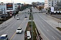
| Road design | two paved lanes in each direction of travel, mostly separated by a green median |
| Technical specifications | |
| Street length | 3.3 km |
The Ungererstraße is about 3.3 km long street in Munich's Schwabing .
description
It leads (parallel to the Englischer Garten ) from Leopoldstrasse to Münchner Freiheit in a north-easterly direction past the Ungererbad and the north cemetery to Freimann, past the Studentenstadt to the intersection with the Frankfurter Ring / Föhringer Ring at the so-called Tatzelwurm , a bridge structure to and exit for the A9 . From there, the street continues northwards as Situlistraße and later becomes Freisinger Landstraße . The Protestant Church of the Redeemer is located at Ungererstraße 15 , and at Ungererstr. 187 is the Catholic Church of St. All Saints, in Ungererstraße 131 the Greek Orthodox Metropolis - All Saints Church. The New Israelite Cemetery is located in the northern part to the west of the road . The subway stops are at the Ungererstraße Dietlindenstraße , North Cemetery , Old Heath and student city of U6 . There are 30 architectural monuments on Ungererstraße, see: List of architectural monuments in Schwabing

Münchner Freiheit
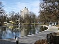
Ungererbad

Church of the Redeemer

Greek Orthodox Church of All Saints

North Cemetery
Student city
Frankfurter Ring

Tatzelwurm


history
Ungererstraße was previously called Landshuter Straße and Freisinger Landstraße , before it was named in 1899 after August Ungerer (1860–1921), the engineer and owner of the Ungererbad.
In 1886 August Ungerer opened the Ungererbahn in what was then Freisinger Landstrasse , which was the first electric tram in Munich to connect the Schwabinger Würmbad (today Ungererbad) with the horse-drawn tram network at the Schwabinger Großwirt. In 1895 the Ungererbahn was replaced by a new horse-drawn railway line that continued on the Freisinger Landstrasse to the north cemetery. In 1900 the tram route in Ungererstrasse was the last horse-drawn tram route in Munich to be switched to electrical operation. In 1917 the tram was extended from the Nordfriedhof on Ungererstraße to Frankfurter Ring. In the course of the construction of the underground, the route used by tram line 6 from 1935 onwards between Münchner Freiheit and Schenkendorfstraße was relocated to the parallel Leopoldstraße and Berliner Straße and the section from Nordfriedhof to Freimanner Platz was closed. In 1967, with the section from Schenkendorfstrasse to Wendeschleife at Nordfriedhof, the last tram line on Ungererstrasse was shut down. Since 1970 the route of the underground line 6 to the Alte Heide underground station has run under Ungererstraße and in the north section above ground parallel to Ungererstraße.
From 1901 to 1949 the rail connection from the JA Maffei locomotive factory in Hirschau to Munich-Schwabing station crossed Ungererstraße south of Schenkendorfstraße with a level crossing . There was a track crossing with the tram tracks .
Web links
Individual evidence
- ↑ Reinhard Bauer: Schwabing. The district book. 2nd Edition. Bavarica-Verlag Dr. Reinhard Bauer, Munich 1997, ISBN 3-923395-06-X , p. 32.
- ^ Markus Trommer: The history of the Munich tram. from: tram.org , January 29, 2000, accessed October 11, 2016.
- ↑ Frederik Buchleitner: Forgotten Tram Lines: The '6er' to Freimanner Platz. on: tramreport.de , June 30, 2015, accessed on October 11, 2016.
- ^ "Maffei-Gleis" Schwabing. ( Memento from October 12, 2016 in the Internet Archive ) on: kocaurek.de
Coordinates: 48 ° 10 ′ 39 ″ N , 11 ° 36 ′ 6 ″ E