
On the hard
_-_Milbertshofen_-_Am_Hart.png)
Am Hart is the northernmost of the three subdistricts of the Munich district 11 Milbertshofen-Am Hart .
location
The Am Hart district extends north of Munich's north ring , between Ingolstädter Strasse in the east and Schleißheimer Strasse in the west, to the northern outskirts of the city on the A99 . It thus borders on Oberschleißheim in the north, Schwabing-Freimann in the east, Milbertshofen in the south and Feldmoching-Hasenbergl in the west.
description
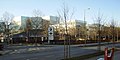
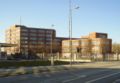
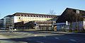
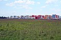
In 2015, 29,029 people lived in the Am Hart district, which corresponds to a population density of 4,199.8 inh / km². Since the 1990s, the Nordhaide settlement has been built for several thousand residents on the southwestern part of the open space that still exists there, the Panzerwiese . In the north there is the hardelwood forest area . A number of former workers' settlements from the interwar period, such as the Harthof , Am Hart (scenic Hart, wooded hill), Kaltherberge and Neuherberge are also characteristic. Opposite the BMW Research and Innovation Center (FIZ), on the corner of Knorrstrasse and Troppauer Strasse, a sculpture is reminiscent of the so-called Milbertshofen Jewish settlement . In the south is the Euro industrial park . The medical academy of the Bundeswehr is located in the Ernst von Bergmann barracks on Neuherbergstrasse . The Reconciliation Church is located on Hugo-Wolf-Straße , St. Gertrud is located on Weyprechtstraße 75 and the Church of the Fourteen Holy Helpers is located on Karlsbader Straße 3 . In the Sudetendeutschestraße 40 the Wirtshaus am Hart with beer garden and cabaret. The Bavarian State Office for the Protection of the Constitution is located at Knorrstrasse 139 . The Dominikuszentrum was opened in 2008, the Mira shopping center in 2009, the Nordhaide school center in 2015 and the Munich-North high school opened in 2016 . The Harthofanger green area is located north and south of Weyprechtstrasse . Underground stations in the district are the U2 Harthof and the U2 Am Hart .
The cultural center 2411 , which opened in 2012 and serves as the common cultural center for the districts of Feldmoching-Hasenbergl (24) and Milbertshofen-Am Hart (11), is not in this district, but in the Hasenbergl district .
Research and innovation center
Bavarian State Office for the Protection of the Constitution

Euro industrial park

Dominic Center

Mira

Nordhaide school center

Wirtshaus am Hart

Memorial for the Milbertshofen Jewish Camp
Ernst von Bergmann barracks
Nordheide

Panzerwiese
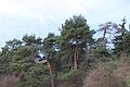
Hardelwood

Harthofanger
.JPG)


history
The northern part of the district (north of Munich's north ring) used to belong mainly to the Feldmoching community ; only Kaltherberge and adjacent areas on today's Ingolstädter Strasse were part of the Milbertshofen community. The original name should come from Reinhartingen . Some colonists settled on Schleissheimer Strasse in the 19th century. The ammunition depot of the Bavarian Army, known as the powder tower, had existed there since 1838 . The district takes its name from the so-called "Reichskleinsiedlung" Am Hart, which was built by the National Socialists from 1933 onwards. A city council resolution of October 10, 1933 provided for the construction of a small imperial settlement "next to Ingolstädter Strasse ", which was to be given the official name "Am Hart". The settlement was opened on September 8, 1936. Almost 340 almost identical single-family houses for workers were built around the area on Ingolstädter Straße. After the Second World War, the addition "Reichskleinsiedlung" was deleted. From 1917 to 1974 the Alabama Depot was located at Am Hart. In the 1980s it became known throughout Germany as a cultural venue under the name Alabama Hall . The Panzerwiese was used for military purposes until the end of the 1980s. More than 2,500 new apartments have been built in Nordhaide since 2003. The right infrastructure was created with the Dominikuszentrum, the Mira shopping center, the culture center 2411 and the Nordhaide school center.
Web links
Individual evidence
- ↑ https://www.citypopulation.de/php/germany-munchen_d.php
- ↑ http://www.muenchen.de/rathaus/Stadtverwaltung/Direktorium/Stadtarchiv/Publikationen/Von-Allach-bis-Zamilapark/Einleitung-Geschichte/Bezirk11.html
- ↑ http://www.muenchen.de/stadtteile/am-hart.html
Coordinates: 48 ° 11 ′ 47.3 " N , 11 ° 34 ′ 30.3" E