
Nordhaide


The Nordhaide is a settlement area in the north of Munich , which belongs to the city district 11, Milbertshofen-Am Hart . It is located on the corner of Schleissheimer Strasse and Neuherbergstrasse in the Harthof area or the south-western part of Panzerwiese and is often referred to as the same.
Features of the Nordhaide
The Nordhaide is mainly used as a residential area. The quarter was built on around 30 hectares. Until 1990 the area was used as a military training area. In total, more than 2500 apartments for 6,500 people have been built since 2003, including 545 places in the student residence on Felsennelkenanger. The housing offer consists of a mixture of publicly subsidized and privately financed apartments. The Nordhaide has a school center and several day-care centers, a children's and youth leisure center and the Dominikus church center .
In the west the district borders on the Dülferanger to the Hasenbergl , north west is the prince axis of the goldsmith square . A new district center on the Nordhaide was created around the Dülferstraße subway station through the construction of the Mira shopping center and adjacent buildings.
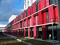
Dormitory


Individual evidence
- ↑ Picture gallery: Nordhaide , Süddeutsche Zeitung - website. Retrieved February 21, 2014.
- ↑ http://www.muenchen.de/rathaus/Stadtverwaltung/Referat-fuer-Stadtplanung-und-Bauordnung/Projekte/Nordhaide.html
- ↑ ( Page no longer available , search in web archives: "Report on the housing situation in Munich 2008-2009", p. 77. )
- ^ "Department for Urban Planning and Building Regulations - PLAN HA II / 12 Urban Development Measures" (PDF file; 100 kB)
Coordinates: 48 ° 12 ′ 43 ″ N , 11 ° 34 ′ 1 ″ E