
Milbertshofen (district part)
_-_Milbertshofen_-_Am_Hart.png)
Milbertshofen is the south-east of the three districts of the higher Munich district of the same name, 11 Milbertshofen-Am Hart .
location
The Milbertshofen part of the district extends north of the Petuelring / Petuelpark , between Schleißheimer Straße in the west and Ingolstädter Straße in the east, to Munich's Nordring in the north. It thus borders on the district of Am Hart in the north, Schwabing-Freimann in the east, Schwabing-West in the south and Am Riesenfeld in the west.
description
20,150 people live in Milbertshofen (2015). It has a population density of 10,478.2 inh / km² [2015]. Due to the renovation of many residential complexes and new construction of modern apartments, the differences to neighboring Schwabing have recently been blurring . Since the traffic on the busy Petuelring has been routed underground through the opening of the Petuel Tunnel , Schwabing and Milbertshofen have been connected by the Petuelpark green corridor.
The Euro-Industriepark is located on Ingolstädter Strasse . The Milbertshofen cultural center was opened in 2005, and in 2007 the adjacent square was named Curt-Mezger-Platz . A weekly market takes place there every Friday from 1 p.m. to 6 p.m. In Milbertshofen is the Alte ( Alter St.-Georgs-Platz ) and New St.-Georgs-Kirche ( Milbertshofener Platz ), the Evangelical Lutheran Church of Thanksgiving on Curt-Mezger-Platz and St. Lantpert in Torquato-Tasso-Str . 40. On 20./21. In October 2007, the BMW Welt opened its doors at the Petuelring . The BMW Museum is also located there . TSV Milbertshofen is located on the Petuelring . The Milbertshofen district center is located on Piccoloministraße . There is a calisthenics facility at Korbinianplatz . There is an elevated bunker at Schleißheimer Straße 281 .
Underground stations in the district are the Milbertshofen underground station and the Frankfurter Ring underground station on the U2 line .

Petuelpark
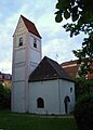
Old St. George's Church

New St. George's Church

Schleissheimer Strasse 271-273
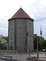
Bunker Schleissheimer Strasse

Georgenschwaigstrasse 42
Dewetstrasse 18

BMW world

BMW Museum

Milbertshofen cultural center
.jpg)


history


Milbertshofen was first mentioned in 1149 or 1152 as "Ilmungeshoven". The word probably emerged from Illungshof's deliberately unclear pronunciation . Illungshof was the name of a hermit farm to which one was forcibly relocated because of illness or as a punishment, understandable that the residents did not necessarily want to announce this. Another interpretation is: "Hof des Ilbunch / Ilbung / Ilmung" or "Höfe der Ilbunge". The first mention of this name happened in a document with which around 1140 Count Konrad I von Valley handed over his entire property at Ilmungeshofen to the Schäftlarn monastery for the salvation of his and his parents' soul . Because the area of this donation could only be used as pastureland, the monastery turned it into a cattle yard, i.e. a Schwaige, which was named after St. George St. Georgenschwaige.
The St. Georgenschwaige also included peasants who had to pay taxes, whose grains were stored in the storerooms of the Fronhof, administered by a master and lay brother, until they were ground in nearby mills. As a meal he received part of the grain brought, which was called the mill mazze . So it was soon called Mühlmazzhof, from which the place name Mühlmatzhofen - Milbertshofen arose. Later names were: 1310 Mülingshoven, 1325 Mülbenhoven, 1336 Mulmantzhoven and 1468 Milberzhofen.
Between 1466 and 1630 the property belonged to the Keferloh family. In 1658 Milbertshofen was sold to Elector Maximilian II Emanuel for 30,000 guilders . On January 10, 1668, Elector Ferdinand Maria elevated St. Georgenschwaige zu Milbertshofen to the rank of Hofmark .
Around 1800 Milbertshofen only had 432 inhabitants. After Milbertshofen had been just a Schwaige for centuries , the expansion of the later district of Munich did not begin until 1800, when Elector Max IV. Joseph handed the estate over to four Waldsassen farmers. A church belonging to Schwaige was first mentioned in 1360. Remnants of the old Georgskirche , built in the early 16th century, are the only remaining witnesses of Milbertshofen’s nucleus. The center of early Milbertshofen is on Alten St.-Georgs-Platz , between Moosacher Straße and Motorstraße.
In 1905 the TSV Milbertshofen was founded. In 1910 Milbertshofen received city status. Just three years later, on April 1, 1913, the city of Milbertshofen was incorporated into Munich. A year earlier, the New St. George's Church on Milbertshofener Platz had been inaugurated. During the Nazi dictatorship, from 1941 onwards, there was a barrack camp in Milbertshofen for Jewish citizens, who were deported from there to various concentration camps . Erected from March to August 1941, from September 1941 to August 1942 it served as a residential ghetto for the Jewish residents of Munich, who had meanwhile been “demented”, and finally as a collection camp for the deportations. The first two large deportations from Munich on November 20, 1941 to Kaunas (Lithuania) and on April 4, 1942 to Piaski (Poland) took place from the nearby Milbertshofen train station .
In the 1980s, the Munich punk scene met in the backyard of Nietzschestraße 7b . The punk band Freizeit 81 also played there .
Web links
Individual evidence
- ↑ https://www.citypopulation.de/php/germany-munchen_d.php
- ↑ http://www.muenchen.de/dienstleistungsfinder/muenchen/1078240
- ↑ Julian Raff: Closing the gap on Piccoloministraße. In: Sueddeutsche Zeitung . February 27, 2019, accessed April 16, 2019 .
- ↑ http://www.total-lokal.de/pdf/80331_89_01_10_02.pdf
- ↑ http://www.muenchen.de/rathaus/Stadtverwaltung/Direktorium/Stadtarchiv/Publikationen/Von-Allach-bis-Zamilapark/Einleitung-Geschichte/Bezirk11.html
- ^ Christian Jocher-Wiltschka: History, data, facts. In: sueddeutsche.de . November 7, 2011, accessed October 13, 2018 .
- ↑ http://www.total-lokal.de/pdf/80331_89_01_10_02.pdf
- ↑ Milbertshofen - Am Hart. In: sueddeutsche.de . May 11, 2012, accessed October 13, 2018 .
- ^ Wilhelm Volkert (ed.): Handbook of Bavarian offices, communities and courts 1799–1980 . CH Beck, Munich 1983, ISBN 3-406-09669-7 , p. 601 .
- ↑ Nicole Graner, Milbertshofen: A whole quarter in your pocket. In: sueddeutsche.de . April 14, 2016, accessed October 13, 2018 .
Coordinates: 48 ° 10 ′ 58.2 ″ N , 11 ° 34 ′ 21 ″ E