
At the giant field
_-_Milbertshofen_-_Am_Hart.png)
Am Riesenfeld is the westernmost of the three subdistricts of the Munich district 11 Milbertshofen-Am Hart .
location
To the north of the course of the Petuel Tunnel , the district of Am Riesenfeld borders further to the east, separated by Korbinianstrasse and Schleißheimer Strasse , on the neighboring Milbertshofen district . In the north it is separated from the Lerchenau district by the tracks or part of Wilhelmine-Reichard-Strasse , and in the west by Landshuter Allee and the abandoned tracks from the Moosach district . In the southwest, the border between the Am Riesenfeld district and the Neuhausen-Nymphenburg district runs first along the Willi-Gebhardt-Ufer to the Spiridon-Luis-Ring, which forms the western boundary of the Olympic Park at the western foot of the larger Olympiaberg, and along this to Ackermannstrasse. In the south, the border to Schwabing-West runs along the curve of Ackermannstraße to Winzererstraße , which together with Lerchenauer Straße to the Petuel tunnel also forms the south-east border to Schwabing-West.
profile
At the giant field is marked by the Olympic Park (with Olympic Tower , Olympic Hall , Olympic Stadium , Olympic Ice Sport Center , Sea Life Munich , Olympic Swimming Pool , Olydorf , Olympic Training Center in Bavaria ), BMW (with BMW Welt , BMW Tower , BMW Museum , BMW Group Classic , the BMW plant ) and the student quarters of Oberwiesenfeld , Am Oberwiesenfeld and Olympic Village . 27,049 people live in Am Riesenfeld (2016). It has a population density of 6,255 inhabitants / km² [2016].
The dense development in the Olympic Village enables quiet, child-friendly living, as the car traffic within the residential area (on Connollystrasse or Helene-Mayer-Ring ) runs in the built-up basement below the pedestrian level. With the Nadisee , Munich's smallest swimming lake is also located in the Olydorf . The ecumenical church center is located at Helene-Mayer-Ring 23 . The Christl-Marie-Schultes-Weg, a pedestrian and cycle path underpass under the north ring of the railway connects Wilhelmine-Reichard-Strasse with the street Am Oberwiesenfeld. The tunnel links the southern Lerchenau with the Oberwiesenfeld underground station. The Adolf Kolping Vocational School is also located there. The Munich Caribes train in the northern part of the central university sports facility and the sports center of the Technical University of Munich . In 2017, the place of remembrance for the Olympic assassination attempt was opened. Bavaria's largest beach volleyball facility is located in the Olympic Park . The Leonardo Royal , the headquarters of Knorr-Bremse and the Westwing Group, as well as the MO82 hotel are located on Moosacher Strasse . The Giesinger Bräu brewery is located on Detmoldstrasse . In 2011, the state capital of Munich acquired a 6.7 hectare area around the Munich Olympiastadion train station from Deutsche Bahn . The aim is to improve the cycle path network in Munich and create a high-line- like park aisle towards the Dreiseenplatte . The Munich Olympic Walk of Stars is located at Willi-Daume-Platz . The entire area is connected to the U3 line via the Olympiazentrum underground station and the Oberwiesenfeld underground station .
- Events
Larger concerts and sporting events take place in the Olympiahalle and the Olympiastadion . The Impark Summer Festival , Theatron Festival , Munich Mash , the SattelFest , the Munich Midsummer Night's Dream and other concerts take place annually on Coubertinplatz in between . Coubertinplatz is also the starting point for numerous running events such as the Munich Marathon , the Wings for Life World Run Munich, the Spartan Race Munich, the Red Bull Crashed Ice , the New Year's Eve Munich , the Munich company run or the B2RUN German company run championship . See also: Events in the Olympic Park
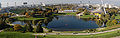
Olympic Park

Olympic Hall, Olympic Stadium and Olympic Swimming Pool
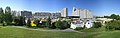
Olympic village with student quarter

Nadisee

Central university sports facility

BMW World, BMW Tower and BMW Museum
BMW Group Classic
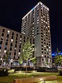
MO82

Headquarters of the Knorr-Bremse Group

Green route at the abandoned train station Munich Olympiastadion

Munich marathon


history


In 1800 the Schwaige, first mentioned in 1764, named St. Georgenschwaige (1568 St. Georgen, 1620 near St. Georgen; see New St. George's Church (Milbertshofen) #History ) was sold to four colonists from Upper Palatinate. On the property that was exposed after the destruction, the settlement with the name "Riesenfeld", which is now known as the "old Riesenfeld" , was built at the Kanalknie ( Nymphenburg-Biedersteiner Canal ) at today's corner of Petuelring and Belgradstrasse . This area became part of the former municipality of Schwabing in 1818 and incorporated into Munich in November 1890.
Today's area Am Riesenfeld was first named on January 8, 1800 as "Risenfeld". It goes back to the couple Andrä von Riß, court chamber councilors in Freising and Theresia, who on June 12, 1796 bought the Bleiche, which had been operating since 1790 according to the Dutch (English) system, at the Kanalknie from the brothers Franz Xaver and Joseph Lunglmayr. Andrä von Riß died in 1798. His widow and children sold the property again on January 8, 1800, called "izt Risenfeld". The Bad Georgenschwaige restaurant was later set up in the former Bleichhaus.
A new settlement called Riesenfeld was later built north of the canal east of Lerchenauer Straße, but it was located in Milbertshofen and was incorporated into Milbertshofen in 1913. In 1941 the bunkers Lerchenauer Strasse and Anhalter Platz were built. In 1996, as part of the redistribution of the city districts, most of the northern Oberwiesenfeld , which lies between Landshuter Allee and Lerchenauer Straße and until 1992 belonged to the Neuhausen-Oberwiesenfeld district, became the Am Riesenfeld district . The area, which in the period from 1966 to 1972 on the occasion of the games of the XX. The Olympic Games, which were completely redesigned in 1972 , are today dominated by the sports facilities, the Olympic Parkharfe and the large Olympic mountain to the south of the Georg-Brauchle-Ring, and to the north of the ring by the Olympic Village and the area of the central university complex. In the past, the area that was used in the period from 1966 to 1972 on the occasion of the XX. 1972 Olympics was completely redesigned and was previously used as a military base, north of the Nymphenburg-Biederstein Canal, a large airfield. The first commercial airport in Munich was located on this airfield from 1929 to 1939 and it was used until 1945 to test the aircraft engines manufactured by BMW in the neighboring plant . After World War II, the airfield was only used by the US armed forces until 1957, before it housed general aviation until 1968.
Others
Munich's Riesenfeldstrasse is named after the Am Riesenfeld district.
Web links
Individual evidence
- ↑ https://www.citypopulation.de/php/germany-munchen_d.php
- ↑ New street names: An engineer and Bavaria's first female aviator . Abendzeitung-muenchen.de. February 6, 2014. Retrieved December 13, 2015.
- ↑ https://www.tz.de/muenchen/stadt/milbertshofen-am-hart-ort43344/vom-schandfleck-zur-beachvolleyball-anlage-auf-internationalem- level-8715181.html
- ↑ https://www.sueddeutsche.de/muenchen/muenchen-giesinger-braeu-oktoberfest-bier-milbertshofen-1.4487084
- ↑ merkur.de: Skaters want to go to the old Olympic train station , from the Münchner Merkur from December 23, 2015, accessed on December 25, 2015
- ↑ New cycle path connections for Munich - municipal department acquires land from Deutsche Bahn . muenchen.de. November 2, 2011. Archived from the original on March 16, 2014. Retrieved March 16, 2014.
- ↑ http://www.muenchen.de/rathaus/Stadtverwaltung/Direktorium/Stadtarchiv/Publikationen/Von-Allach-bis-Zamilapark/Einleitung-Geschichte/Bezirk11.html
Coordinates: 48 ° 11 ′ 0 ″ N , 11 ° 33 ′ 19.6 ″ E