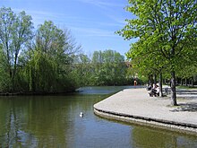
Nymphenburg-Biederstein Canal


The Nymphenburg-Biedersteiner Canal is a canal in Munich and part of the northern Munich canal system . It was laid out at the beginning of the 18th century under the reign of Elector Maximilian II. Emanuel and, together with the Nymphenburg Canal, is an example of baroque landscape architecture in Munich.
history
At the beginning of the 18th century, Elector Max Emanuel commissioned a large network of canals around Munich to connect his residences Nymphenburg and Schleissheim by water. The canals were designed in such a way that they were suitable for both the transport of goods and people and thus represented an alternative to horse - drawn carriages . In addition to soldiers, he is said to have used prisoners of war from the Turkish wars for his work. In addition, branch channels, u. a. the Turkish trench , dug.
At the time the canal was being built, the area around the future Munich districts of Nederling and Gern was hardly populated; Nederling consisted of only two farms and the construction of the canals was carried out independently of the needs of the farmers in the area. The canal soon became a magnet for bathers: in 1856, Bad Gern was opened on Klugstrasse . Due to its high attraction as a bathing area, several restaurants with beer gardens and affiliated microbreweries opened in the following years. The last of the small breweries on the canal was taken over by Löwenbräu AG at the beginning of the 20th century .
In the vicinity of the castle, the canal ran through the Oberwiesenfeld , which was used as an artillery training area in the late 19th century. A military swimming school was set up on the canal for soldiers from the adjacent barracks.
In 1901 the canal between Leopoldstrasse and Ungererbad was built over with the Schwabing freight station . After the station was dismantled, the canal was exposed again at the end of the 1980s and integrated into the design of the newly built residential area on Berliner Straße. The Schwabinger See , which is fed by the Nymphenburg-Biedersteiner Canal, was created with the residential area .
course
The channel branches at the Nymphenburg Palace of the Nymphenburg Canal and drives the investments of the Nymphenburg porcelain manufactory in the northern Schlossrondell. It then heads north-east, where it divides the districts of Nederling and Gern from one another. Roads running in parallel, as well as footpaths and cycle paths to the right and left of the canal, border its banks. It flows on Dantebad and at Dante Park along, passes under the Dachauerstraße and Landshuterallee and continues its path to the northeast down to the Olympic Park , where he is to the Olympic widened. At the beginning of the lake there is a diversion into a southern subterranean side channel running parallel to the lake, which after the bridge at the level of the Olympic ice rink again has an introduction into the channel. After about a kilometer, the canal narrows again and now runs eastwards, past the Georgenschwaige / Luitpoldpark and parallel to the Petuelpark . Sturgeon stones were inserted along the Petuelpark to increase the oxygen content.
At the east end of the Petuelpark the canal makes a sharp bend to the southeast and runs diagonally under Leopoldstrasse and Berliner Strasse, feeds the Schwabinger See and flows through the municipal open-air swimming pool Ungererbad. Then the canal flows through the eponymous Schwabing district of Biederstein. At the Zum Brunnwart restaurant on Biedersteiner Straße, the canal flows down a step in the area and drives the small hydropower plant on Biederstein . On the west side of the English Garden the canal flows into the Schwabinger Bach . The end section of the canal between the small hydropower plant and the confluence with the Schwabinger Bach will also beCalled "black paints".
Coordinates: 48 ° 10 ′ 31 ″ N , 11 ° 33 ′ 48 ″ E
literature
- Christine Rädlinger : History of the Munich city streams . Published by the Munich City Archives. Verlag Franz Schiermeier, Munich 2004, ISBN 3-9809147-2-0 .
- Franz Schiermeier: Munich city streams. Travel guide to the lifelines of a city . Verlag Franz Schiermeier, Munich 2010, ISBN 978-3-9813190-9-5 .
- Sonja Niesmann: Beacon for bats , article in the Starnberg local edition of the Süddeutsche Zeitung. Online version from August 11, 2017.


