Luitpoldpark (Munich)


The Luitpold Park is a park with an area of 33 hectares in the northwest of Munich city district Schwabing-West .
description
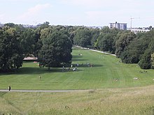
In the northern part of the park, directly west of Scheidplatz , there is the 37 m high Luitpoldhügel , a green vantage point with a view over northern Munich. The Georgenschwaige open-air swimming pool bordering the site , but also the Olympic tower and the Olympic stadium can be seen. The hill was created from the rubble of Munich, which was badly damaged in World War II.
In the north, the site borders on an allotment garden and, via the Georgenschwaige outdoor pool, on the Nymphenburg-Biederstein Canal and the Petuelring . The Bamberg House is on the western edge of the park . The Pumuckl fountain is located on the playground with a hedge labyrinth north of the Bamberg house . Belgradstrasse borders the park in the east .
In the southeast are the Willi-Graf-Gymnasium and the Sophie-Scholl-Gymnasium .
In the south (separated by Karl-Theodor-Straße) there is the three-hectare park Bayernplatz .
history
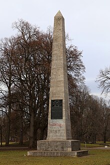
In 1909, the Munich magistrate decided to build what was initially known as Nordpark on a fallow area on the outskirts of the city as a green space for the then rapidly growing Maxvorstadt . The core of the park was to be an obelisk surrounded by 90 lime trees and 25 oaks as a memorial in honor of the Bavarian Prince Regent Luitpold . In 1911 the park was opened on the occasion of the Prince Regent's 90th birthday with the planting of the 90th linden tree. The obelisk was designed by Heinrich Düll and Georg Pezold from Lower Franconian shell limestone and bronze. Near the Borschtallee is the Wilhelm Götz monument , a pillar with a relief portrait of the geographer Wilhelm Götz flanked by a bench that was designed in 1913 by the Munich sculptor Hans Hemmesdorfer .
Until the Luitpoldhügel was filled in, the northern border of the Luitpoldpark was the Stiftprobst-Türk-Straße, which no longer exists today, which went from Schleißheimer Straße to Borschtallee, and the eastern border was Borschtallee, which at that time still ran to Rümannstraße.
Web links
- muenchen.de: 100 years of Luitpoldpark at a glance
Individual evidence
- ↑ The secret park. In: sueddeutsche.de . July 5, 2011, accessed October 13, 2018 .
- ↑ LH Munich, building department: The Luitpoldpark: 100th anniversary in 2011
- ↑ Hemmersdorfer, Hans . In: Hans Vollmer (Hrsg.): General lexicon of fine artists from antiquity to the present . Founded by Ulrich Thieme and Felix Becker . tape 16 : Hansen – Heubach . EA Seemann, Leipzig 1923, p. 368 .
- ↑ City map "Blitzführer through Munich, the capital of movement". G. Seyferle publishing house in Munich 2 SW.
Coordinates: 48 ° 10 ′ 10 ″ N , 11 ° 34 ′ 9 ″ E

