
Petuelring
| Petuelring | |
|---|---|
|
|
|
 |
|
| Petuelring on Lerchenauer Strasse | |
| Basic data | |
| State capital | Munich |
| Townships | Schwabing-West , Milbertshofen |
| Created | 1961 |
| Newly designed | 1971 1997-2004 |
| Hist. Names | Petuelstrasse |
| Name received | 1962 |
| Connecting roads | Schenkendorfstrasse , Georg-Brauchle-Ring |
| Cross streets | Leopoldstrasse , Eduard-Schenk-Strasse, Knorrstrasse , Belgradstrasse , Ostermayrstrasse, Frohschammerstrasse, Schleissheimer Strasse , Hanselmannstrasse, Riesenfeldstrasse, Sankt-Blasien-Strasse, Lerchenauer Strasse |
| Numbering system | Orientation numbering |
| Buildings | Municipal Lion-Feuchtwanger-Gymnasium , BMW four-cylinder , BMW Museum , cube of the Lenbachhaus |
| Subway station | Petuelring |
| use | |
| User groups | Pedestrian traffic , bicycle traffic , car traffic , public transport |
| Road design | Petuel tunnel / Petuelpark |
| Technical specifications | |
| Street length | 2.0 km |
The Petuelring is a 2.2 km long road in the north of Munich and part of the Mittlerer Ring . It runs between Georg-Brauchle-Ring and Schenkendorfstrasse
location
The Petuelring is about four kilometers north of Munich city center. The ring runs in a west-east direction and marks the border between the districts of Milbertshofen and Schwabing-West . The eastern part of the ring runs in the Petuel tunnel . The Petuelpark partially lies above this tunnel .
course
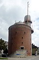
The Georg-Brauchle-Ring coming from the Olympiapark merges into the Petuelring at the tunneled intersection Lerchenauer Straße (Munich-Zentrum - Feldmoching-Hasenbergl ). The BMW Museum is also located here . After 500 meters, the access ramps to the Petuel Tunnel, in which the Petuelring runs, begin at Riesenfeldstrasse. A high bunker from 1941 is located here.
On the surface, the two single-lane ramps lead to the Schleißheimer Strasse intersection . From here, the Petuelring runs along the Nymphenburg-Biederstein Canal in four lanes (without separating the directional lanes) over the Petuel Tunnel in a northeastern direction. After 400 meters the ring reaches the junction of Knorrstrasse / Belgradstrasse . The road then joins the Petuel tunnel via connecting ramps. Following the further course in an easterly direction, the Petuelring ends in the Petuel Tunnel under the Leopoldstrasse intersection and there merges into Schenkendorfstrasse . From here the road (via the Isarring ) has a connection to Bogenhausen , or (in an easterly direction of travel via a side tunnel) to the A 9 towards Nuremberg / Berlin .
Between Knorrstrasse / Belgradstrasse and Leopoldstrasse, the Petuelpark was created over the Petuel tunnel . The Georgenschwaige outdoor pool is also located there, and the Luitpoldpark adjoins it to the south .
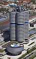
BMW Museum
Riesenfeldstrasse and Petuelring

Nymphenburg-Biederstein Canal

Petuelpark
Bad Georgenschwaige
Luitpoldpark


traffic
As part of the Middle Ring, the Petuelring is very important in the Munich transport network. Up to 107,500 vehicles pass the ring every day. This is expanded to consist of four lanes. In the partial area of the Middle Ring, the directional lanes are separated. On the surface above the Petuel Tunnel, the traffic load is 30,000 vehicles per day.
In the western area between Lerchenauer and Schleißheimer Straße the underground line U 3 runs directly under the street. The Petuelring underground station is located south of the Schleißheimer Strasse intersection .
history
The Petuelring was just a better dirt road in the 19th century. Only when Ludwig II was fortified did it become a real street. It is named after Ludwig Petuel sen. and Ludwig Petuel jun. The father moved to Milbertshofen in 1868 and made a fortune here, a large part of which he invested in Milbertshofen’s buildings. His son also repeatedly made land available for urban development projects.
The Petuelring emerged from Petuelstrasse. This began place at the former Triburger ( 48 ° 10 '27.69 " N , 11 ° 33' 36.68" O ). It followed the Nymphenburg-Biederstein Canal and turned into Schenkendorfstrasse at the Belgradstrasse intersection.
The Petuelring was completed in 1961. A site from the Petuel Foundation was also included. A tram underpass was built between the stops on Rümannstrasse and Keferloherstrasse for line 8 at that time and was designated the Petuel Tunnel ( 48 ° 10 ′ 40.66 ″ N , 11 ° 34 ′ 29.51 ″ E ).
Since the traffic load increased steadily, the planning for a tunnel was started in the 1980s. These were stopped after the local elections in 1990 when the Greens participated . After the 1996 referendum “The ring needs three tunnels”, the citizens of Munich decided to build the Petuel tunnel and against the red-green majority of the town hall.
In 1993 the city closed the first Petuel tunnel, which was served by tram lines 12 and 13.
Petuel tunnel
Construction of the new Petuel Tunnel began in 1997, which led to disruptions from the construction site. The opening ceremony took place on June 6, 2002. Both the Petuel Tunnel and the road above it in the Schleißheimer Strasse area to Leopoldstrasse continue to bear the name Petuelring.
Petuelpark
.jpg)
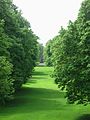
After completion of the construction work on the tunnel, the 7.4 hectare Petuelpark was built between Knorrstrasse / Belgradstrasse and Leopoldstrasse from 2002 to 2004. The elevated part is dominated by extensive grass areas, on the lower level so-called "theme gardens" have been set up.
Namesake
The street is named after several members of the Petuel family. Ludwig Petuel Sr. was a brewer from Freising and had a canal path expanded, on whose route the Petuelring runs today. His son Ludwig jun. and his wife Karolina bequeathed their entire fortune to the city of Munich in the 1930s due to childlessness. It has been administered by the Ludwig and Lina Petuel Foundation since the 1950s .
literature
- City of Munich Department of Urban Planning and Building Regulations (Ed.): Mittlerer Ring . Urban and open space planning study. Munich May 2000 ( pdf [accessed December 1, 2009]).
Web links
- Building Department Munich Petuelpark
- Side of the Petuelpark
- How won - that's how Ring residents pay the bill for tunnel construction, Munich tenants' magazine ( Memento from June 9, 2008 in the Internet Archive )
- Petuelpark , sueddeutsche.de from July 5, 2008
Individual evidence
- ↑ http://www.muenchen.de/stadtteile/milbertshofen.html
- ↑ map archive ( Memento from June 22, 2004 in the Internet Archive )
- ↑ Richard Strauss Tunnel: The Millions Grave on the Ring. DIE ABENDZEITUNG, September 6, 2009, accessed on January 9, 2018 .
Isarring with Biedersteiner Tunnel , White Bridge , John F. Kennedy Bridge and Effner Tunnel | Richard-Strauss-Straße with Richard-Strauss-Tunnel | Leuchtenbergring with Leuchtenbergring tunnel | Innsbrucker Ring with Innsbrucker Ring Tunnel | Chiemgaustraße | Tegernseer Landstrasse | Candidstraße with candid bridge and Candidtunnel | Brudermühlstrasse with Brudermühlbrücke , Brudermühlsteg and Brudermühl tunnel | Heckenstallerstraße with tunnel Heckenstallerstraße | Luise-Kiesselbach-Platz with Luise-Kiesselbach-Tunnel | Garmischer Strasse with tunnel Garmischer Strasse | Trappentreustraße with Trappentreutunnel | Donnersbergerbrücke | Landshuter Allee with Landshuter Allee tunnel | Georg Brauchle Ring | Petuelring with Petuel tunnel | Schenkendorfstrasse
Coordinates: 48 ° 10 ′ 40 ″ N , 11 ° 34 ′ 19 ″ E