Georg Brauchle Ring
| Georg Brauchle Ring | |
|---|---|
| Street in Munich | |
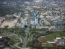
| Georg-Brauchle-Ring with skyscraper Uptown Munich | |
| Basic data | |
| State capital | Munich |
| Borough |
Moosach Milbertshofen-Am Hart |
| Created | 1969-1971 |
| Name received | 1971 |
| Connecting roads | Petuelring , Wintrichring |
| Cross streets | Lerchenauer Strasse , Walter-Berthe-Weg, Lillian-Board-Weg, Sapporobogen, Hanns-Braun-Brücke, Landshuter Allee , Riesstrasse, Mirjam-David-Strasse, Hanauer Strasse , Dachauer Strasse |
| Numbering system | Orientation numbering |
| Buildings | Uptown Munich , Olympiastadion , Olympiahalle , Olympiaturm , BMW Welt |
| Subway station | Georg Brauchle Ring |
| use | |
| User groups | Pedestrian traffic , bicycle traffic , car traffic , public transport |
| Technical specifications | |
| Street length | 2.7 km |

The Georg-Brauchle-Ring is a street in the north of Munich . The section between Landshuter Allee and Petuelring is part of the Middle Ring , the western part leads to the western bypass of the only partially realized outer ring .
location
The Georg-Brauchle-Ring is located about five kilometers north of Munich city center and crosses the districts of Moosach and Milbertshofen-Am Hart from west to east. He cuts through the Olympic Park .
The western part of the ring shows a very differentiated urban planning concept. In the city's highest skyscraper, Uptown Munich , the mobile communications group O₂ has its headquarters, and the Bavarian State Sports Association is in the House of Sports . The Bavarian State Criminal Police Office , the Munich waste management company , the Moosach bus depot and a congress hall for Jehovah's Witnesses are also located on Georg-Brauchle-Ring. There are also two petrol stations and various car dealerships in this section of the route.
The eastern part of the route runs exactly between the Olympic venues and the Olympic Village . Since this section of the route was developed and built at the same time as the construction of the facilities for the 1972 Summer Olympics , they form a single unit in terms of both space and design.
course
The Georg-Brauchle-Ring begins in the west in the Moosach district at the Dachauer Straße intersection (connection between Munich center and Moosach center). From the Neuhausen-Nymphenburg district , the Wintrichring turns into the Georg-Brauchle-Ring at this intersection. After 600 meters, the ring reaches the Hanauer Straße junction (entrance to the Olympia shopping center ). The Uptown Munich is located on the north side of the street. After 500 meters the ring reaches the confluence with Riesstrasse, after another 150 meters the underpass of the abandoned track system to a former gas works of the Stadtwerke München . The ring then reaches Landshuter Allee at the so-called "Olympic Cross". There is a connection to Dachau to the north via the B 304 . The “Mittlerer Ring” ( B 2 R ) runs to the south .
The intersection with Landshuter Allee forms the border with the Milbertshofen-Am Hart district . The Georg-Brauchle-Ring then crosses the Olympic Park as the “Middle Ring” . The Olympic Stadium , the Olympic Hall and the Olympic Tower are located directly on Georg-Brauchle-Ring . In this section three wide pedestrian bridges cross the Georg-Brauchle-Ring, which has 8 lanes. BMW Welt is located on the northeastern edge of the Olympic Park . The Georg-Brauchle-Ring ends at the tunneled intersection of Lerchenauer Straße (connection from Munich center with Feldmoching-Hasenbergl ) and turns into the Petuelring towards Schwabing-Freimann .
traffic
The Georg-Brauchle-Ring as part of the Middle Ring is of great importance in the Munich transport network.
In addition to several bus lines, the U1 underground line has had a station of the same name on Georg-Brauchle-Ring (near Hanauer Strasse) since 2003 , which was designed by Franz Ackermann . The Olympiazentrum stop of the U3 underground line is around two kilometers east of it, also in the immediate vicinity of Georg-Brauchle-Ring.
State of development
| Section of | Section to | Total tracks |
Directional lane separated |
plan-free |
|---|---|---|---|---|
|
|
|
4th | + | - |
|
|
|
8th | + | + |
history
The Oberwiesenfeld with Munich's first airport (1931–1968) used to be on what is now the eastern section of the route, while the Moosach gas works was located in the north .
In the years 1969 to 1971 the Georg-Brauchle-Ring was created together with the Olympic site. The middle ring was therefore passable along its entire length.
Namesake
The street is named after Georg Brauchle (1915–1968), who was Munich's second mayor from 1960 until his untimely death. During his tenure, he campaigned for Munich to apply for the 20th Olympic Games in 1972. That is why the section of the Middle Ring near the Olympic site is named after him.
Web links
Individual evidence
- ↑ State Capital of Munich Department for Urban Planning and Building Regulations Urban Development Planning HA1 (Ed.) Mittlerer Ring Urban and open space planning study . Munich May 2000
Coordinates: 48 ° 10 ′ 34 ″ N , 11 ° 32 ′ 35 ″ E


