Richard-Strauss-Strasse (Munich)
| Richard-Strauss-Strasse | |
|---|---|
| Street in Munich | |
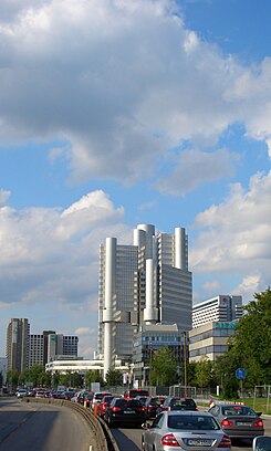
| Richard-Strauss-Straße with Hypo-Haus and Arabellapark | |
| Basic data | |
| State capital | Munich |
| Borough | Bogenhausen |
| Created | around 1960 |
| Newly designed | 1972 (construction of the Mittlerer Ring), 2009/10 (redesign after tunnel construction) |
| Name received | 1915 |
| Connecting roads | Leuchtenbergring , Effnerplatz |
| Cross streets | Zaubzerstrasse, Lisztstrasse, Mühlbaurstrasse, Stuntzstrasse, Donaustrasse, Schreberweg, Widderstrasse, Denninger Strasse, Salomeweg |
| Places | Šumava Square |
| Numbering system | Orientation numbering |
| Subway stations | Böhmerwaldplatz , Richard-Strauss-Straße |
| use | |
| User groups | Pedestrian traffic , bicycle traffic , individual traffic , public transport |
| Technical specifications | |
| Street length | 1.6 km |
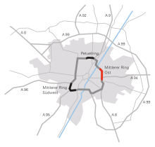
The Richard-Strauss-Straße is a section of the middle ring in Munich district of Bogenhausen . It connects the Effnerplatz with the Leuchtenbergring ; the main traffic on the middle ring has been flowing in the Richard Strauss tunnel below the road since 2009 .
Course and building
Richard-Strauss-Straße continues the Leuchtenbergring, which ends at the intersection with Prinzregentenstraße , to the north. It leads straight through Parkstadt Bogenhausen , Munich's first high-rise housing estate, completed in 1957. Opposite the Parkstadt Bogenhausen (towards the city) is the actual Bogenhausen on the banks of the Isar and the Böhmerwaldplatz with the U4 underground station of the same name . This is followed by the green area of Denninger Angers , the "Forum Bogenhausen" of Münchner Bank eG (formerly Siemens AG ) delimits the Arabellapark with the 114 m high Hypo-Haus as a striking building on the right side of the street . Richard-Strauss-Straße joins Effnerplatz , which connects this section of the Middle Ring with the Isarring .
traffic
The underground stations Richard-Strauss-Straße and Böhmerwaldplatz of the underground line U4 are located under Richard-Strauss-Straße , which contribute to the development of the adjacent residential and commercial buildings.
Zaubzerstraße, which is divided by Richard-Strauss-Straße, was connected by a pedestrian bridge as part of the expansion of the Middle Ring. On January 21, 1981 this was damaged by a truck; It was later demolished and replaced in August 1982 by a pedestrian traffic light at Lisztstrasse.
tunnel
Richard-Strauss-Straße is largely tunnelled by the 1.5 km long Richard-Strauss-Tunnel, which opened on July 18, 2009.
After the tunnel was completed, the surface was redesigned until 2010. This changed the appearance and structure of the neighboring Arabellapark and Bogenhausen quarters, as an avenue was planted above the tunnel and only one lane was created in each direction for traffic.
The route of the subway , which partly runs under Richard-Strauss-Straße, was also difficult in the tunnel construction, but during the construction of which a later road tunnel had already been taken into account. The north-western entrance of the Richard-Strauss-Straße underground station had to be demolished for the tunnel construction because the tunnel location had changed compared to the originally planned plan.
Namesake
The Richard-Strauss-Straße is named after the German composer Richard Strauss ( 1864 - 1949 ), named, a native of Munich. The southern part was named as early as 1915, while the northern part was called Fichtelgebirgstrasse from Böhmerwaldplatz until 1958 .
Planning
On the former 20,000 square meter Siemens site at Richard-Strauss-Strasse 76, two skyscrapers are being built, 100 and 60 meters high with 26 and 15 floors respectively, connected by a 50 meter high and 100 meter long connecting wing. This will become the new headquarters of the Bavarian Supply Chamber (BVK) with 72,000 square meters of floor space. 1300 people will work in the high-rise buildings when they are completed in 2024.
Web links
Individual evidence
- ↑ Abendzeitung : Articulated lorry tore away the bridge, January 30, 1981, page 7
- ↑ Small Chronicle of Traffic in Munich - 1981. In: muenchen.de. City of Munich, District Administration Department, July 26, 2009, archived from the original on July 26, 2009 ; accessed on October 22, 2017 .
- ↑ ( page no longer available , search in web archives ) sueddeutsche.de
- ↑ https://www.muenchen.de/rathaus/dam/jcr:cb1e6d76-e4c2-486b-8ab9-6d67ec170921/mro_anwohnerinfo.pdf
- ^ Hans Dollinger: Die Münchner Strasseennamen, 6th edition 2007, Munich: Südwest Verlag, ISBN 978-3-517-08370-4 , p. 257
- ↑ cf. Roland Krack (Ed.): The Parkstadt Bogenhausen in Munich, Munich 2006: Volk Verlag, ISBN 978-3-937200-10-1 , esp.p. 12, 34, with excerpt from the JRO city map 1953
- ↑ BVK headquarters: "2050 more cars every day" , Unser Bogenhausen, September 17, 2019. Accessed October 27, 2019.
Coordinates: 48 ° 8 ′ 27 ″ N , 11 ° 36 ′ 55 ″ E


