
Denninger Anger

The Denninger Anger is a green space in the borough 13 Bogenhausen the Bavarian state capital Munich . It has an area of about 20 hectares .
location
The Denninger Anger runs through the city district 13 in an east-west direction and thus forms a lane for the air supply into the city. It extends from Richard-Strauss-Strasse in the west to the Munich East – Munich Airport railway line in the east. This puts it in the area of three Munich districts : Bogenhausen , Denning and Zamdorf . Denninger Strasse and Daglfinger Strasse form the northern border, while the Parkstadt Bogenhausen , Steinhausen , Kolonialsiedlung and Zamilapark settlements border the green area in the south .
description

The Denninger Anger is divided into three sections, which are located in the different parts of the city.
The western part in the Bogenhausen district extends from Richard-Strauss-Strasse to Weltenburger Strasse. The Parkstadt Bogenhausen connects to the south and the Arabellapark to the north . This oldest part was laid out in the early 1960s. After the Arabellapark was built in the 1980s, it was expanded. Here, Denninger Anger is designed as a hilly undulating city park with well-tended paths, benches, groups of trees and bushes and meadows. There are two allotment gardens on Schreberweg on the southern edge, and the “Rothof” sports area, built in 1983, on Weltenburger Straße.
The middle part of Denninger Angers in the Denning district between Weltenburger Strasse and Friedrich-Eckart-Strasse is the least developed part of the green corridor. Narrow paths lead through fields and meadows. Since October 2018, a section between Weltenburger Strasse and Pühnstrasse has been expanded into a public green area.
The eastern part of Denninger Angers between Friedrich-Eckart-Straße and the railway line is in the Zamdorf district. It was completed in 1993 after the Zamilapark settlement was built south of it from 1983 to 1991 . This part of the park is sometimes referred to as Zamilapark itself . It contains a geology garden with the most important Bavarian rock types, a small lake and a sports facility and was named the most beautiful green area in Bavaria in the mid-1990s.
photos
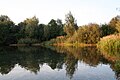
Eastern part, lake

View of St. Klara in Zamdorf

Geology garden


See also
literature
- Willibald Karl (Ed.): Villages on the brick land . Daglfing-Denning-Englschalking-Johanneskirchen-Zamdorf. Buchendorfer, Munich 2002, ISBN 978-3-934036-90-1 .
Web links
- Denninger Anger on the website of the Association for District Culture in the Munich Northeast eV
Individual evidence
- ↑ New construction of the public green area on Pühnstrasse. In: Town hall look around. City of Munich, October 19, 2018, accessed on October 20, 2018 .
Coordinates: 48 ° 8 ′ 40 ″ N , 11 ° 37 ′ 59 ″ E