
Schwabinger Bach

The Schwabinger Bach is the westernmost of the brooks that flow through the English Garden in Munich . Unlike until 1945, when the section of the Eisbach up to the waterfall was called the Schwabinger Bach, it begins on Von-der-Tann-Straße as a continuation of the Köglmühlbach , which takes up the water of the western Stadtgrabenbach ( Lage ), flows on the Japanese Tea house and touches the Eisbach ( Lage ) at an artificially created waterfall and flows through the Schönfeldwiese, which has become known as the nudist area . After the confluence of the Entenbach ( Lage ) it flows around the Kleinhesseloher See on the western edge of the English Garden before it crosses under the Mittlerer Ring . When split for a short time, it then serves to supply the Lodenfrey Park with energy . The Nymphenburg-Biederstein Canal joins the north cemetery on the left side ( Lage ). At the Aumeister , Schwabinger Bach and Mühlbach ( Lage ) separate, which runs through the site of the former Floriansmühle outdoor pool and from which the Schleißheim Canal is fed and which continues north of the emergency outlet as Garching Mühlbach , they flow through the Isar floodplains and flow near Garching near Munich in the Isar ( location ).
![]() Map with all coordinates: OSM | WikiMap
Map with all coordinates: OSM | WikiMap
photos

Schwabinger Bach at the Japanese tea house
Eisbach and Schwabinger Bach

Schwabinger Bach, looking south

Schwabinger Bach in the Hirschau

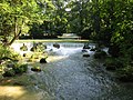
Schwabinger Bach in midsummer


.JPG)
literature
- Christine Rädlinger : History of the Munich city streams . Ed .: City Archives Munich. Verlag Franz Schiermeier, Munich 2004, ISBN 978-3-9809147-2-7 . P. 184
- Franz Schiermeier: Munich city streams . Travel guide to the lifelines of a city. Verlag Franz Schiermeier, Munich 2010, ISBN 978-3-9813190-9-5 .
Web links
Coordinates: 48 ° 10 ′ 44 ″ N , 11 ° 36 ′ 40 ″ E