
Winzererstrasse
| Winzererstrasse | |
|---|---|
|
|
|
 |
|
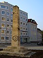
| Former casino building on Winzererstraße at the corner of Schwere-Reiter-Straße | |
| Basic data | |
| State capital | Munich |
| Townships | Schwabing-West , Maxvorstadt |
| Name received | 1891 |
| Connecting roads | Hessstrasse |
| Cross streets | Schellingstrasse , Görresstrasse, Georgenstrasse , Lothstrasse , Agnesstrasse, Wormser Strasse, Elisabethstrasse, Hohenzollernstrasse , Schwere-Reiter-Strasse , Mitterwieserstrasse, Herzogstrasse , Clemensstrasse , Saarstrasse, Hildeboldstrasse, Ackermannstrasse, Hornstrasse |
| Numbering system | Orientation numbering |
| Buildings | City Archives Munich , Obelisk (war memorial of the 2nd Infantry Regime at the intersection with Lothstrasse and Georgenstrasse ) |
| use | |
| User groups | Pedestrian traffic , bicycle traffic , individual traffic , public transport |
| Technical specifications | |
| Street length | 2.0 km |
The Winzererstraße is an approximately two-kilometer road in the Munich districts Maxvorstadt and Schwabing .
description
Winzererstraße begins on Heßstraße at Maßmannpark and runs almost parallel to Schleißheimer Straße , in the north the street ends today, after crossing Ackermannstraße , southeast of Olympiaberg .
There are 11 monuments on it , z. B. the barracks building of the Prinz-Leopold-Kaserne or the obelisk at the corner of Winzererstraße / Lothstraße / Georgenstraße .
The Bavarian State Ministry for Labor and Social Affairs, Family and Integration is located at Winzererstraße 9, Wood Research Munich ( TU Munich ) is located at Winzererstraße 45, the collection department of the Munich tax office is located at Winzererstraße 47a, the City Archives are located at Winzererstraße 68 , at number 52 a branch of the Federal Office for Goods Transport , at Winzererstraße 106 the regional labor court and the labor court in Munich.
Obelisk in the triangle Winzererstraße / Lothstraße / Georgenstraße
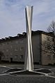
Stele diagonal (1986) by Ben Muthofer
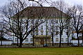
Munich City Archives at Winzererstraße 68

Baroque-style residential complex at Winzererstraße 35

Crew building

Barracks building, former part of the Prinz-Leopold-Kaserne at Winzererstraße 43

Part of a Makoré tree with a diameter of 4 m in front of the wood research in Munich as an object for viewing
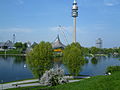
Olympic Park


history

The street is named after the knight and Landsknechtführer Winzerer , who prevented the peasant wars from spreading to Bavaria in 1525 . It runs on part of the Oberwiesenfeld .
From 1902 the Bavarian army moved into the Prinz-Leopold-Kaserne .
The casino ("Officer's restaurant") at Winzererstraße 41 - used as a chemical factory until a fire in the 1980s - was later a popular film set, for example with director Rainer Werner Fassbinder or for Schimanski Tatorte. At that time, the film people simply completed the ailing walls with paper mache and the like for the shooting .
Around 1905 there were parts of the barracks of the 1st Pioneer Battalion between Lothstraße and Elisabethstraße , which had not yet been fully developed, along Winzererstraße, which formed part of the Oberwiesenfeld barracks district east of Infanteriestraße . At that time, Winzererstraße was already expanded to Herzogstraße , but not asphalted.
North of Herzogstraße, the North Deller KG dairy was founded in 1941, immediately south of the rubble mountain , which a few years later became the Olympiaberg and which existed until the end of the 1990s. In 2000 the dairy was demolished and the residential complex at the Olympiapark was built.
After 1946 to 1992, the Winzererstrasse between Lerchenauer Strasse and Lothstrasse formed the border between the districts of Schwabing-West and Neuhausen -Oberwiesenfeld.
It was only with the construction of Ackermannstrasse at the end of the 1960s as part of the construction work for the 1972 Summer Olympics that the northern section of Winzererstrasse (from the height of house number 89) up to Lerchenauer Strasse was paved.
In the 1970s, the access from Lerchenauer Strasse to Winzererstrasse was closed to cars. Later, the area below the Olympiaberg from today's residential complex at the Olympiapark to Lerchenauer Strasse was rebuilt, so that the road now ends at the level of the residential complex.
From 1980 to 1981, an 11-meter-long section of a Tieghemella heckelii tree from Africa was set up for research purposes at Winzererstraße 45 at the Holzinstitut .
Since 1996 the Winzererstraße between Lerchenauer Straße and Ackermannstraße has been the border between the districts of Schwabing-West and Milbertshofen-Am Hart .
Web links
Individual evidence
- ↑ List of monuments for Munich (PDF) at the Bavarian State Office for Monument Preservation, monument number D-1-62-000-4064
- ↑ Winzererstrasse. In: sueddeutsche.de. May 17, 2010, accessed June 30, 2018 .
- ↑ http://www.wochenanzeiger.de/article/141823.html
- ^ Richard Bauer / Eva Graf: "Munich at a Glance: Aerial Photography from 1890 to 1935", Volk Verlag Munich, ISBN 978-3-86222-010-6
- ↑ Foundation stone laid for residential complex on Olympiaberg in Munich May 17, 2000
- ↑ myheimat.de, excerpt from the diary: 09.09.2012 bike tour through Munich
Coordinates: 48 ° 9 ′ 37.5 ″ N , 11 ° 33 ′ 42 ″ E