
Helene Mayer Ring
| Helene Mayer Ring | |
|---|---|
|
|
|
 |
|
| Helene-Mayer-Ring shopping street | |
| Basic data | |
| State capital | Munich |
| Borough | Milbertshofen-Am Hart |
| Created | 1971 |
| Name received | 1971 |
| Cross streets | Lerchenauer Strasse , Connollystrasse , Nadistrasse, Straßbergerstrasse |
| Numbering system | Orientation numbering |
| Buildings | Olympia Tower , Ecumenical Church Center in the Olympic Village |
| use | |
| User groups | Pedestrian traffic , bicycle traffic , individual traffic |
| Road design | Well systems |
| Technical specifications | |
| Street length | 490 m |
The Helene-Mayer-Ring is a street in the Olympic Village of the Olympic Park Munich .
description
The road is accessible to pedestrians on the surface and to motorists underground. The Helene-Mayer-Ring is the shopping street of the Olympiadorf with 36 retail units. The Olywelt eG u. a. engaged by buying stores. The colored "Media Lines" (yellow on the Helene-Mayer-Ring), a pipe system running on stilts by the Austrian architect Hans Hollein, serve as a guide. At Helene-Mayer-Ring 4 there is the 88-meter-high Olympia Tower , at Helene-Mayer-Ring 10 there is another high-rise building 76 meters high. The Ecumenical Church Center of the Olympic Village is located at Helene-Mayer-Ring 23/25 . In the east, the Helene-Mayer-Ring flows into Lerchenauer Straße . Connollystraße branches off to the west .
The street is named after the German-American fencer and Olympic champion Helene Mayer .

Ecumenical Church Center on Helene-Mayer-Ring

Olympia-Tower at the beginning of the Helene-Mayer-Ring
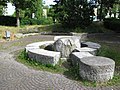
Fountain water features Steinquader (Wolfgang Zacharias), Helene-Mayer-Ring / corner Lerchenauer Straße
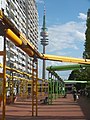
"Media Lines" pipe system as a guide


.jpg)

Individual evidence
- ↑ Successful model. In: sueddeutsche.de. July 31, 2015, accessed August 3, 2018 .
- ↑ https://www.sueddeutsche.de/muenchen/muenchen-olympiadorf-wohnen-1.4558800
Coordinates: 48 ° 10 ′ 55 ″ N , 11 ° 33 ′ 10 ″ E