
Oberföhring
Oberföhring is a district of the Bavarian capital Munich and belongs to the district 13 Bogenhausen .
location
Oberföhring is located in the north-northeast of Munich - on the right bank of the Isar - and is part of the district 13 Bogenhausen . Within this district, Oberföhring borders on the districts of Bogenhausen , Englschalking and Johanneskirchen .
history
Oberföhring is the earliest documented district of today's Munich. He is first mentioned on July 3, 750 as ad feringas ; In 783 the court feringa was named in a document by Duke Tassilos III. , which is part of the tradition book of the Upper Austrian monastery Mondsee . In 903 the Oberföhringer Hof was transferred from King Ludwig IV to the Regensburg Episcopal Church . In the area of Oberföhring there was already a trade route with a river crossing over the Isar in Roman times . Trade caravans mainly transported salt from the Salzburg area to rich Augsburg . You could easily cross the river here at normal water levels. This is evidenced to this day by names such as Salzstraße, Salzsenderweg and An der Salzbrücke. At the turn of the millennium, the landlord, the Bishop of Freising , had a bridge built and levied a bridge toll for the crossing . This bridge toll made Oberföhring a prosperous town. The Bavarian Duke Heinrich the Lion destroyed the bridge in 1156 and instead built his own a few kilometers upstream in order to withhold the bridge toll himself from then on. Oberföhring belonged to the Hochstift Freising until secularization in 1803 .
In the middle of the 18th century, when there was a sharp anti-liberal mood in Munich, local tourism developed from the city to Oberföhring on three days of the week, where uncensored newspapers were circulated and there was no need to be afraid of informers at the next table. This fact was due to the fact that the place belonged to the Principality of Freising , on which the Bavarian censorship had no direct influence. This was called the Foehringer Days .
After secularization in Bavaria and the dissolution of the Freising Monastery, Oberföhring became part of the Electorate of Bavaria . Through the municipal edict of 1818, it became an independent political municipality with the district of St. Emmeram .
In 1910 the community had 1,056 souls in 215 households; in addition, from 1870 600 to 800 Italian seasonal workers came to the 17 brick factories on the loess clay tongue in the east of the community. The community area was 3.63 km². This demarcation largely corresponds to today's district 8692 Oberföhring with an area of 3.65 km². The last mayor of the independent community was Fritz Meyer from 1899 to 1913. On July 1, 1913, Oberföhring was incorporated into Munich .
The current urban district 13.1 Oberföhring of the Bogenhausen district has a smaller area of 2.21 km². The population was 13,179 as of December 31, 2015.
Townscape

The special location on the high bank of the northern Isar with the walking paths leading directly to the Isar floodplains and the Isar canal invites many spontaneous visitors from the region and from Munich to this district. The nearby weir , from which the Middle Isar Canal is wrested from the Isar , is also a popular place to stay; Here you can cross the Isar on foot and get to the northern part of the English Garden . The 22 hectare leisure area “Isarinsel Oberföhring” extends between the Isar and the canal from the weir to the city limits at the Herzog-Heinrich-Brücke. It was laid out in the years 1976 to 1978 according to the plans of the Munich landscape architect Gottfried Hansjakob together with the city gardening authority under the direction of Josef Wurzer. Just a few minutes' walk downstream of the Isar canal you get to the St. Emmeram district with the St. Emmeram mill and the neighboring St. Emmeram memorial chapel .
The Catholic Church of St. Lorenz (consecrated to St. Lawrence), largely designed in the early “peasant baroque” of the early 17th century , is the center of the parish of the same name and is located in the old village center of Oberföhring, which is an inviting and peaceful idyll a little off the main thoroughfare could keep. Here you will also find the stately parsonage (19th century), the former school building (now a meeting place) and the Bernheimer Schlösschen, a mansion almost on the high bank of the Isar floodplain, which has been the seat of various social institutions since the recent past.
The graves of the sculptor Adolf von Hildebrand , architect of the Wittelsbacher Fountain on Lenbachplatz in Munich, and the media entrepreneur Leo Kirch are located in the cemetery near St. Lorenz .
The striking water tower on the high bank next to the Bernheimerschlößl (Muspillistraße 19) from 1902/1903 with a cylindrical water room on a conical base was demolished in 1962.
In the south of Oberföhring beyond today's Wahnfried-Allee was the Priel, a forest and hunting area of the Freising bishops, which bordered directly on the Bavarian Bogenhausen . The brick factory there was already located in the Bavarian region. In 1812 the entire priel came to Bogenhausen.
The Goetz Collection is also located in Oberföhring and moved into a museum building by Pierre de Meuron and Jacques Herzog in 1993. Opposite is the Oberföhring Bürgerpark (formerly the "Oberföhringer Hospital", which was dissolved by the construction of the Bogenhausen Clinic in 1983/84), a park-like area with loosely developed buildings. It is dedicated to cultural purposes and the home of several clubs.
cards
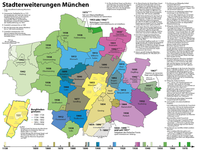
Historical demarcation: incorporation of Oberföhring into Munich in 1913

The district 8692 Oberföhring largely corresponds to the former municipality
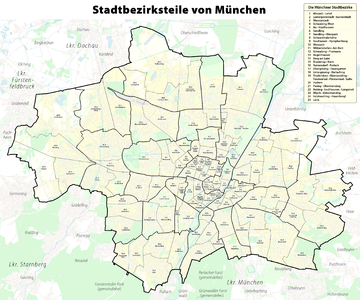
Today's demarcation: The district 13.1 Oberföhring within the Bogenhausen district


Culture
- Goetz Collection , Oberföhringer Straße 103
- Bürgerpark Oberföhring , Oberföhringer Straße 156
- The small puppet stage in the Oberföhring Bürgerpark, Oberföhringer Straße 156
literature
- Fritz Lutz : Oberföhring. For the 75th anniversary of the incorporation of Oberföhring. Buchendorf: Buchendorfer Verlag 1988.
- Fritz Lutz: From the past of the Priel near Munich-Bogenhausen. Krailling near Munich: self-published in 1991, without ISBN.
- Fritz Lutz: St. Emmeram near Munich-Oberföhring, a former pilgrimage and school ceremony. Krailling near Munich: self-published, undated (1992), without ISBN.
Web links
- Oberföhring on the website of the Association for District Culture in the Munich Northeast eV
- Goetz Collection
- 25 years of Bürgerpark Oberföhring on www.muenchen.de
Individual evidence
- ↑ Martin Bitschnau , Hannes Obermair : Tiroler Urkundenbuch, II. Department: The documents on the history of the Inn, Eisack and Pustertal valleys. Vol. 1: Up to the year 1140 . Universitätsverlag Wagner, Innsbruck 2009, ISBN 978-3-7030-0469-8 , p. 89 No. 120 .
- ↑ NordOst Kultur München: Oberföhring: History
- ^ Localities directory of the Kingdom of Bavaria, with alphabetical register of places, Munich, 1904 , column 218
- ^ Wilhelm Volkert (ed.): Handbook of Bavarian offices, communities and courts 1799–1980 . CH Beck, Munich 1983, ISBN 3-406-09669-7 , p. 601 .
- ↑ Statistical Office of the City of Munich ([email protected])
- ↑ [email protected] (evaluation of the population register )
- ^ Fritz Lutz : Oberföhring. For the 75th anniversary of the incorporation of Oberföhring. Buchendorf 1988: Buchendorfer Verlag, p. 66.
Coordinates: 48 ° 10 ′ N , 11 ° 37 ′ E