Glacier Point

Glacier Point is a lookout point above the Yosemite Valley , in California , USA . It is located on the south side of the valley at an altitude of 2200 m above sea level and almost 1000 m above Curry Village. From here you have an overwhelming view of Yosemite National Park and the Yosemite Valley, including Yosemite Falls , Half Dome , Vernal Fall , Nevada Fall , and Clouds Rest .
geology

The top of the ledge is completely free of debris, but the slopes below and the basin to the west are filled with moraines , as are the wooded slopes above. The origin as glacier rubble is certain because these rocks come from the Little Yosemite Valley and the High Sierra .
There are three types of debris deposited by the glaciers:
- The most common stones are rounded chunks and angular fragments of them. All heavily weathered quartz-monazite , the light-colored granite from which not only the Half Dome is made, but also the other rocks of the small Yosemite Valley and the neighboring heights.
- There are a few chunks of coarse-grained, highly silicate granite that is yellow-brown in color and turns a distinct pink when weathered. There is only one place in the High Sierra above Yosemite from which they can come, Mount Clark, about 12 km east of Glacier Point in the Illilouette Basin.
- Finally, there are fragments of yellowish quartzite and gray slate , the origin of which could be located on the northern foothills of Mount Clark.
Access
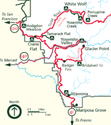
Glacier Point can be reached from the valley on Glacier Point Road. In summer the viewpoint is regularly overrun with tourists. There are also bus tours that last around four hours. The street is usually open from June to October. In winter the road to Glacier Point is closed due to snow and you can only get there (from the Badger Pass Ski Area) on skis or snowshoes.
Glacier Point can also be reached via the so-called Four Mile Trail , which overcomes the approximately 1000 meters in altitude in about 7.5 km. You can get to Glacier Point via this moderate to arduous route, even if the road is closed. It should be noted, however, that the path can be extremely dangerous in ice and snow and is usually closed by the park administration between December and May. Another approximately 13 km long path leads over the Panorama Trail into the valley, passing the Nevada and Vernal Falls. Long-distance hikers can also use signposts on the Panorama trail and the Pohono Trail.
See also
Individual evidence
- ↑ a b c F.E. Matthes: Evidences of an earlier ice invasion . In: Geologic History of the Yosemite Valley . United States Department of the Interior (USGS), 1930.
- ↑ a b Yosemite Auto Touring . NPS. Retrieved May 16, 2008.
- ^ Glacier Point Tours . DNC Parks & Resorts at Yosemite, Inc .. Retrieved May 16, 2008.
Web links
- Road Conditions for Yosemite National Park
- Photos from Glacier Point
- QTVR of Yosemite Valley, including a good view of Glacier Point
Coordinates: 37 ° 43 ′ 51 ″ N , 119 ° 34 ′ 22 ″ W.
