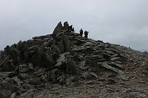
Glyder Fawr
| Glyder Fawr | ||
|---|---|---|
|
The summit of Glyder Fawr |
||
| height | 1001 m ASL | |
| location | Gwynedd , Wales | |
| Mountains | Snowdonia | |
| Coordinates | 53 ° 6 '3 " N , 4 ° 1' 47" W | |
|
|
||
| particularities | 5th highest mountain in Wales | |
Glyder Fawr is the highest peak in the Glyderau mountain range at 999 m and 1001 m respectively, and the fifth highest in the Snowdonia National Park .
Location and surroundings
The Glyder Fawr is located in Snowdonia National Park in the far northwest of Wales in the local county of Gwynedd . There are several small lakes in the area. The nearest town is Bangor .
Routes to the summit
There are many different routes of varying difficulty to the summit. Tours that include not only Glyder Fawr but also the neighboring peaks are also popular.
The undescribed and sometimes indistinct paths represent a major difficulty, and can easily be lost sight of in bad weather (e.g. fog, snow). In a pinch, artificially heaped stone piles provide orientation to the Devil's Kitchen .
Neighboring peaks
Neighboring peaks are the Tryfan ( 918 m ) in the northeast, the Glyder Fach ( 994 m ) in the east and the Y Garn ( 947 m ) in the northwest, which also guarantee a beautiful view.
Web links
Individual evidence
- ↑ David Else, Sandra Bardwell, Belinda Dixon, Peter Dragicevic: Walking in Britain . Lonely Planet, 2007, ISBN 978-1-74104-202-3 , pp. 318 .
- ↑ a b Britta Schulze-Thulin: Wales: The most beautiful coastal and mountain walks. 50 tours. With GPS data . Bergverlag Rother GmbH, 2013, ISBN 978-3-7633-4429-1 , p. 55 ff .
- ↑ a b SnowdoniaGuide.com

