
Golf Club Punta Ala
| Golf Club Punta Ala | |
|---|---|
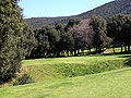
 Green 9 with a view of the sea and the island of Elba |
|
| Place data | |
| Coordinates: | 42 ° 48 '5.2 " N , 10 ° 46' 19.5" E |
| Playable since: | 1964 |
| Architect: | Giulio Cavalsani |
| Par: | 72 |
| Length: | 6168 meters |
| CR / Slope : |
73.8 / 140 |
| Character: | Forest / parkland |
The Golf Club Punta Ala is one of the oldest and most difficult golf courses in Italy. It is located in southern Tuscany near Punta Ala .
history
In 1962 the construction of the golf course began, which was placed on the slope of a wooded hill sloping towards the sea. The forest was cleared over an area of 60 hectares , only a few particularly impressive trees remained as special obstacles on the fairways. Since the course was cut out of the dense vegetation, there was also no need for the otherwise usual years of “growing in” without a golf course appearing bare and rather boring in its early stages.
The square could already be opened in 1964, although building was very complex for the conditions at the time. This resulted in a total of 200,000 m 3 of excavation, 3 km of drainage pipes were laid in 5 km of trenches and the irrigation system consisted of 450 sprinkler heads with 16,000 m of pipelines. According to the club, it is said to have been the first fully automatic irrigation system of its kind in Europe at the time. In 1992 it was modernized and converted to computer control.
The greens were sown with agrostis grass, the fairways are made of a Bermuda variety. In terms of landscape, the golf course is widely praised as it allows spectacular views of the sea and the island of Elba and impresses with the Mediterranean vegetation (pine, stone and cork oaks, strawberry trees, holly). According to the club, the place was once chosen by foreign journalists to be number 5 in Europe in terms of technology and appearance.
Golf aspects
character
Punta Ala is one of the most difficult courses in Italy, which is not only evident from the course rating and slope value, but also from the fact that the course record held by Alessandro Tadini is only 69, i.e. three under par. Normally, narrow golf courses are rather short on difficult terrain, precisely because the terrain does not have long holes and the courses should also be playable for average golfers. This is different in Punta Ala, where long and winding paths were laid in narrow forest aisles and green complexes that were difficult to assess were added.
In addition, the course is very exhausting, because the holes alternately lead from the clubhouse down the hill to the sea and then up again. Most of the strokes must therefore be played uphill or downhill and also from a sloping position, as many fairways also slope sideways. This strong undulation of the terrain, which is often difficult to assess visually, paired with the length of the tracks is certainly the main reason for the high level of difficulty. Water hazards and elaborate bunker landscapes could therefore be dispensed with, but these would not have matched the appearance of a forest landscape anyway.
Special landmarks
A ravine runs right through the golf course and has to be played over in some places. The golfer himself then crosses it with the help of high and relatively narrow, occasionally swaying metal bridges. The castle of Punta Ala can be seen from tee 17 and indicates the ideal line of play. The clubhouse is located at the highest point of the golf course and offers the well-known panoramic view of the sea from the terrace even for non-golfers.
photos

The terrain drops steeply from the first tee. You have to hit the bend to the left exactly, otherwise trees will block the way.

Hole 6 is a long and narrow par 3 through a forest aisle.

Pine trees at hole 14.
A ravine blocks the way to Green 16.

View from tee 17 towards the castle of Punta Ala.


