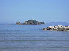
Punta Ala
Punta Ala is a district of the municipality of Castiglione della Pescaia in southern Tuscany . It is located on a headland 21 km northwest of the main town across from the island of Elba , which is about 30 km away and can be clearly seen in good weather.
history
The peninsula called Punta Troia belonged in the Middle Ages to Piombino , a small Principality of the Appiani; this was conquered by Siena . After the fall of Siena to Florence by Cosimo I de 'Medici in 1555, Cosimo had to give up Piombino, which Philip had, according to the contract of July 3, 1557 with Philip II , who claimed some of the Sienese possessions (including the Monte Argentario ) II wanted to return the expropriated Prince Jacopo IV d'Appiano. Jacopo gave Cosimo the small peninsula as a gift for his wife Eleonora of Toledo , but five years later, after her untimely death, the property fell back to the Appiani, who were one of the few regional princes who remained independent from the Grand Duchy of Tuscany.
The three fortifications to protect against pirates - in the north of the Torre Hidalgo , in the south Il Castello and on the rocky island in front of the Torre dello Sparviero - date from this time on the foundations of earlier systems. The terrain, surrounded by the marshland of the Maremma and uninhabitable because of the unsuitable climate, was of purely strategic importance.
After changing ownership after the Appiani died out in Piombino, the Punta Troia peninsula fell to the Habsburgs in 1765 . Ferdinand III. (Tuscany) had the fortifications reinforced and provided more spacious accommodation for the protection troops and their families.
In the course of the great drainage and recultivation program ( la bonifica ) by Grand Duke Leopold II (Tuscany) , a road was built between Piombino and Campiglia in 1841 , and landowners and farmers settled in the now habitable surrounding area. A count named Rosselmini Gualandi from Pisa successfully established the first country estate on Punta Troia with grain cultivation and cattle breeding (cattle and horses). The inhabitants of Scarlino provided labor . The widow bequeathed the property to a non-profit organization in 1919.
After the First World War, in the era of fascism, Italo Balbo bought the entire site. Besides the Gualandi estate, there were only two smaller farms left at that time. The Torre Hidalgo was a naval observatory. Rural everyday life was still tough at that time: the groundwater that could be drawn from a draw well was enough to water the cattle, but to get drinking water you had to walk up to the hill to a spring.
The renaming of the peninsula in Punta Ala goes back to Italo Balbo . He carried out some renovations and extensions of the entire complex, extended the access road, had the area fenced in to keep the cattle, cleared some of the surrounding forests, to add more houses and another manor ( Tre Pini ) as well as storage (today the office is located the SpA Punta Ala). On the other hand, he planted new pine trees, laid a water and electricity line.
After the Second World War, the entire Balbo property was confiscated by the Italian state for "enrichment in the fascist regime". Although the heirs won a restitution process, they still had to sell the complex in 1959, and in the 1960s the transformation into an exclusive holiday center began.
Punta Ala today
Today Punta Ala is characterized by the largest marina on the Tyrrhenian coast with 900 berths, a promenade with shops, cafes and restaurants as well as hotels and apartment complexes of the upper tourist class and luxury class. Regattas, riding and golf tournaments at the Golf Club Punta Ala , Ferrari shows and other social activities take place regularly during the season .
Almost all facilities are closed out of season.
The town center is only accessible to residents and boat owners by car; "Onlookers" must find space in the visitor parking lot above the village.
Web links
Coordinates: 42 ° 48 ′ 7 ″ N , 10 ° 45 ′ 14 ″ E

