Goyder Regional Council
| Regional Council of Goyder | |
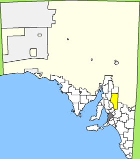
 Location of the Goyder Council in South Australia |
|
| structure | |
| State : |
|
| State : |
|
| Administrative headquarters: | Burra |
| Dates and numbers | |
| Area : | 6,719 km² |
| Residents : | 4,136 (2016) |
| Population density : | 0.6 inhabitants per km² |
| Wards : | 4th |
Coordinates: 33 ° 41 ′ S , 138 ° 56 ′ E The Regional Council of Goyder is a local government area (LGA) in the Australian state of South Australia . The area is 6,719 km² and has about 4100 inhabitants (2016).
Goyder is located in the Lower North Region of South Australia about 140 km northeast of the metropolis of Adelaide . The area includes 64 districts and towns: Aberdeen, Apoinga, Australia Plain, Baldina, Baldry, Booborowie, Bower, Brady Creek, Braemar (Station), Bright, Brownlow, Buchanan, Bundey, Burra , Burra Eastern Districts, Burra North, Canowie, Canowie Belt, Collinsville, Copperhouse, Deep Creek, Dutton, Emu Downs (Hill), Eudunda, Farrell Flat, Franklyn, Frankton, Geranium Plains, Gum Creek, Hallelujah Hills, Hallett, Hampden, Hansborough, Hanson, Julia, Ketchowla, Koonoona, Kooringa, Leighton, Mallet (Reservoir), Mongolata, Mount Bryan, Neales, Neath Vale, Ngapala, North Booborwie, Pandappa, Peep Hill, Point Pass, Porter Lagoon, Robertstown, Rocky Plain, Steinfeld, Sutherlands, Terowie, Thistle Beds, Tracy , Ulooloo, Whyte-Yarcowie, Willalo, Worlds End, Worlds End Creek, Yarcowi and Yongala Vale. The administrative seat of the council is in Burra, where about 900 inhabitants live (2016).
administration
The Goyder Council has seven members elected by the residents of the four wards (three from Burra Ward, two from Eudunda Ward, and one each from Hallett and Robertstown Ward). These four districts are determined independently of the districts. The mayor of the council is also recruited from among the councilors.
Web links
Individual evidence
- ^ Australian Bureau of Statistics : Goyder (DC) (Local Government Area) ( English ) In: 2016 Census QuickStats . June 27, 2017. Retrieved April 20, 2020.
- ^ Australian Bureau of Statistics : Burra (L) (Urban Center / Locality) ( English ) In: 2016 Census QuickStats . June 27, 2017. Retrieved April 20, 2020.