
Granberget
| Granberget | ||
|---|---|---|
 View from the Granberget |
||
| height | 701 m above sea level | |
| location | Värmland County , Sweden | |
| Coordinates | 60 ° 53 '54 " N , 12 ° 44' 9" E | |
|
||

The Granberget is the highest mountain in the historic Swedish province of Värmland , which is part of Värmland County . It is located east of Höljes , in the northern part of the municipality of Torsby .
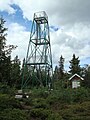
The summit is above the tree line , but still below the tree line is growing, so there still lights birch forest, in Scandinavia the transition from forest to mountains forms. There is a twelve-meter-high observation tower on the summit, which was built in 1993. When the weather is clear, you can see as far as Norway. The mountain is also on the Nordvärmlandsleden hiking route .
The mountain can be reached on foot via the Höljes-Långberget hiking trail, which is 2.5 kilometers long .
photos
Observation tower


