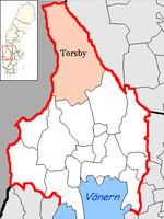
Torsby (parish)
| Torsby parish | |||||
|---|---|---|---|---|---|
|
|||||
| State : | Sweden | ||||
| Province (län): | Värmland County | ||||
| Historical Province (landskap): | Varmland | ||||
| Main place: | Torsby | ||||
| SCB code: | 1737 | ||||
| Residents : | 11,616 (December 31, 2019) | ||||
| Area : | 4,357.4 km² (January 1, 2016) | ||||
| Population density : | 2.7 inhabitants / km² | ||||
| Website : | www.torsby.se | ||||
| List of municipalities in Sweden | |||||
Coordinates: 60 ° 8 ′ N , 13 ° 0 ′ E Torsby is a municipality ( Swedish commun ) in the Swedish province of Värmland County and the historic province of Värmland . The main town of the parish is Torsby .
geography
Torsby is the northernmost municipality in the Swedish province of Värmland. The municipality stretches from the north bank of the Fryken Lakes (which are connected to Vänern) up to the mountains. Within the municipality you quickly pass through several climatic zones.
The geography of the municipality is characterized by a low mountain range, the highest elevations of which reach around 700 m. The municipality is traversed by the Klarälven river.
economy
In addition to forestry, tourism plays an important role for the community. Alpine winter sports facilities are located in Branäs and Hovfjället . In June 2006 a ski tunnel was opened in Torsby . The facility is 1.3 km in length and is also intended for biathlon .
Bigger places
particularities
The municipality has a twin city of the Easter Island . Torsby is the center of the Swedish-Norwegian Finnskogen region , which was settled in the 16th century by Finnish immigrants, the so-called forest fins .
Twin cities
-
 Bømlo
Bømlo
-
 Skjern
-
 Pernå
Pernå
-
 Rautalampi
-
 Großkrotzenburg
-
 Easter island
-
 Bergsjön , district of Gothenburg
Web links
- Official website (German, English, Swedish)
swell
- ↑ Folkmängd i riket, län och kommuner December 31, 2019 at Statistiska centralbyrån
- ↑ Kommunarealer January 1, 2016 at Statistiska centralbyrån (including all inland waters)

