Greaves Peak
| Greaves Peak | ||
|---|---|---|
|
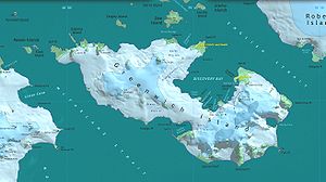
Map of Greenwich Island with Greaves Peak (top left) |
||
| height | 240 m | |
| location | Greenwich Island , South Shetland Islands | |
| Coordinates | 62 ° 27 ′ 15 ″ S , 59 ° 59 ′ 22 ″ W | |
|
|
||
The Greaves Peak is a dark, 240 m high and pointed mountain with twin peaks near the north-western end of Greenwich Iceland in the archipelago of the South Shetland Islands .
Scientists from the British Discovery Investigations mapped the mountain from 1934 to 1935 and gave him the descriptive name of Black Peak (English for Black Lace ). In order to avoid confusion with other objects of the same name, the UK Antarctic Place-Names Committee decided in 1961 to rename it. The new namesake is Alexander Benjamin Greaves, captain of the British sealer Brusso , who operated in the waters around the South Shetland Islands between 1821 and 1822.
Web links
- Greaves peak in the Geographic Names Information System of the United States Geological Survey (English)
- Greaves Peak on geographic.org (English)

