Green Island (Hawaii)
| Green Island | ||
|---|---|---|
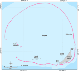
| Map of the Kure Atoll | ||
| Waters | Pacific Ocean | |
| Archipelago | Northwest Hawaii Islands | |
| Geographical location | 28 ° 23 '34 " N , 178 ° 17' 34" W | |
|
|
||
| length | 2.1 km | |
| width | 2.3 km | |
| surface | 78 ha | |
| Highest elevation | 6 m | |
| Residents | uninhabited | |
| Green Island from the Air (1968) | ||
Green Island (Eng. Green Island ) is the main island of the Kure Atoll , the northernmost atoll in the world, in the US state of Hawaii in the northern Pacific Ocean . It forms the end of the Hawaiian Islands and is part of Honolulu City and County .
With an area of 78 hectares, the island combines the majority of the total land area of the atoll (86 hectares). The only other named island is Sand Island to the west. Green Island is located in the southeast of the atoll. The lagoon side is almost straight for 2 km, while the sea side almost describes a quarter circle for 2.5 km. The island is lined with beach all around. The maximum distance from one side to the other is 640 m. The northernmost point of Green Island is called North Point , the westernmost point is West Point . The lagoon just offshore is called the Shallow Lagoon . Behind West Point are two small islands about 1.2 km away, and Sand Island is the same distance behind them. Another small island can be found 400 m behind Sand Island and 3.6 km from Green Island. These land masses make up the entire land area of the Kure Atoll. The next major landmass is the Midway Islands , 91 km to the west and slightly south. Green Island is six meters high.
Green Island has no permanent residents, but is occasionally visited by the United States Fish and Wildlife Service . There is a 1.2 km long paved airstrip , which takes up almost the entire southern part of the island, but can no longer be used. Shipwrecked people have had to be rescued from the island several times. Until 1992 there was a LORAN radio navigation station of the US Coast Guard on Green Island ; there are five buildings and a street on the island. Hundreds of thousands of sea birds and seals live on it, so it is protected and may only be entered for research purposes with the permission of the USFWS. There have been several expeditions of radio amateurs to the island. Since 1993 it has been renaturalized . The ship Paradise Queen II , stranded off the east coast in 1998, lost around 15,000 liters of diesel , which had protracted consequences for the fauna.
The north point of the island at 28 ° 24 ′ 5 ″ N , 178 ° 17 ′ 19 ″ W is the northernmost land point of Hawaii and thus all of Oceania or the continent of Australia and Oceania . This makes Green Island the most northerly island in the Central Pacific and the most northerly of the ocean not in the broadest sense in front of a land mass.
Web links
- Voyage to Kure , expedition to Green Island by Jean-Michel Cousteau
Individual evidence
- ↑ All distances were determined with Google Maps .
- ^ Kure High Point , peakbagger.com
- ↑ Kure Island, Jane Resture


