Honolulu City and County
 US Post Office, Custom House, and Honolulu City and County Courthouse |
|
| administration | |
|---|---|
| US state : | Hawaii |
| Administrative headquarters : | Honolulu |
| Address of the administrative headquarters: |
530 S King St Honolulu, HI 96813 |
| Foundation : | 1907 |
| Demographics | |
| Residents : | 953.207 (2010) |
| Population density : | 613.4 inhabitants / km 2 |
| geography | |
| Total area : | 5509 km² |
| Water surface : | 3955 km² |
| map | |
| Website : www.co.honolulu.hi.us | |
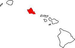
City and County of Honolulu is a county and city in the state of Hawaii in the United States of America : It includes Oʻahu and the northwestern islands of the archipelago. According to the 2010 census, the county had 953,207 residents in an area of 5509 km² in April 2010 . It corresponds statistically to the Honolulu metropolitan area. The county seat of Honolulu County is Honolulu .
Honolulu County has had a partnership with the Philippine capital Manila since 1980 .
Administrative structure
The administrative unit is divided into nine districts . The census-designated places are summarized in the districts. Hawaii is the only state in which CDPs are defined within a municipality.
- District I : ʻEwa , ʻEwa Beach , Honouliuli , West Loch , Kapolei , Makakilo , Kalaeloa , Honokai Hale and Nanakai Gardens , KoʻOlina , Nānākuli , Waiʻanae , Mākaha , Keaʻau , Mākua .
- District II : Mililani Mauka , Wahiawā , Whitmore Village , Mokulē'ia , Waialua , Hale'iwa , Waimea , Pūpūkea , Sunset Beach , Kahuku , Lā'ie , Hau'ula , Punalu'u , Kahana , Ka'a'awa , Kualoa , Waiāhole , Kahalu'u , ' Āhuimanu , He'eia .
- Koolaupoko (District III) : Waimānalo , Kailua , Kāneʻohe .
- District IV : Hawaiʻi Kai , Kuliʻouʻou , Niu Valley , ʻĀina Haina , Wailupe , Waiʻalae-Iki , Kalani Valley , Kāhala , Wilhelmina Rise , part of Kapahulu , part of Kaimukī , Diamond Head , Waikīkī , Ala Moana .
- District V : Kapahulu , Kaimukī , Pālolo Valley , St. Louis Heights , Mānoa , Mōʻiliʻilli , McCully , Kakaʻako , Ala Moana , Makiki .
- District VI : Makiki , a part of Honolulu (Downtown), Punchbowl , Liliha , Pauoa Valley , Nuʻuanu , lewa Heights , Papakōlea , Kalihi Valley , Kalihi .
- District VII : Kalihi , Kapālama , Pālama , Iwilei , Sand Island , Māpunapuna , Airport , Hickam , Pearl Harbor , Ford Island , Āliamanu , Salt Lake , Foster Village , Stadium , Hālawa Valley Estates .
- District VIII : Fort Shafter , Moanalua , Hālawa , ʻAiea , Perl City , Seaview , Crestview , Waipiʻo Gentry .
- District IX : Waikele , Waipahu , Village Park , Kunia , Mililani .
| Thereof: | |
|
|
State institutions
- Honolulu International Airport
- Wheeler Army Airfield
- Kunia Camp
- Kunia Regional SIGINT Operations Center
Adjacent counties
- Maui County to the southeast
- Kauai County in the northwest
National parks
- James Campbell National Wildlife Refuge
- Oahu Forest National Wildlife Refuge
- Papahānaumokuākea Marine National Monument
- Pearl Harbor National Wildlife Refuge
- USS Arizona Memorial
See also
Web links
Commons : Honolulu City and County - collection of pictures, videos, and audio files
Individual evidence
- ↑ US Census Bureau: Honolulu County (English)
- ↑ a b http://files.hawaii.gov/dbedt/census/geo/hawaii_geo_info_1.pdf
- ↑ http://archives.starbulletin.com/2005/12/11/editorial/special2.html
Coordinates: 21 ° 28 ′ N , 157 ° 58 ′ W


