Diamond Head (Hawaii)
| Diamond Head | ||
|---|---|---|
|
Diamond Head, east of Waikīkī |
||
| height | 232 m | |
| location | Oahu Island , Hawaii | |
| Coordinates | 21 ° 15 '43 " N , 157 ° 48' 22" W | |
|
|
||
| Type | Tuff ring | |
| rock | Tufa | |
|
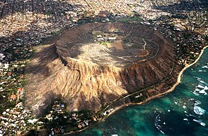
Diamond Head from the air |
||
The Diamond Head , called Lēʻahi in Hawaiian , is a 232 m high tufa formation on the Hawaiian island of Oʻahu and the symbol of Honolulu and Waikīkī . Its English name comes from sailors from the 19th century that the calcite sprinklings with diamonds confused. Maunalua Bay is located between Diamond Head in the west and Koko Head in the east .
Formation of the crater
The sea-side summit, deeply eroded ridges and the egg-shaped crater are evidence of Lēʻahi's dynamic geological history. Oahu was formed from the eruption of two volcanoes 2.5 to 3 million years ago . A period of extensive erosion followed. Remnants of these volcanoes are the Koʻolau and Waiʻanae Range .
After about 2 million years of volcanic inactivity, there were renewed eruptions at the southeastern end of Ko'olau. These eruptions took place near the ocean, where the magma was split into ash and fine particles using water and steam. Ejected into the air and cemented together, tuff rings like the Lēʻahi formed.
It is believed that the Lēʻahi formed in a single eruption 300,000 years ago. The wide saucer-shaped crater covers approximately 1.5 square kilometers (350 acres) and is significantly wider than it is high. The southwestern rim is higher because the ash was blown in that direction by the wind during the eruption. Since the eruption, the slopes have been eroded and worked by rain, wind and sea. Today a coral reef protects the seaward slopes of the crater.
Lēʻahi (Diamond Head) is one of the most famous mountains in Hawaii. 1986 he became a typical example of a tuff ring into a major attraction ( National Natural Landmark ) declared the United States.
Plants and animals at Diamond Head
The semi-arid climate, the steep rocky slopes and the flat crater floor of Diamond Head allow mainly small bushes and herbs to grow. Botanists suspect that the crater was previously covered with forest. Today, however, there are only a few original Hawaiian species left. At the beginning of the 20th century, rainwater formed a small lake in the crater, which was populated by native ducks, coots and cranes.
Most of the plants and animals seen in the crater today were brought to Hawaii in the 19th century. Dominant plants are the kiawe, a tree of the genus Prosopis , and koa haole ( Leucaena leucocephala ). Both plants were introduced as feed for cattle and quickly adapted to the hot, dry conditions. Mainly one sees cardinals , pigeons and sparrows.
The early story
It is said that Hiʻiaka , sister of the fire deity Pele , gave Lēʻahi its name because of the similarity of the summit to the forehead ( lae ) of the ʻahi fish. Another translation is Fire Headland, referring to navigation fires that were lit at the summit to guide canoes as they sailed along the coast. A heiau (temple) at the summit was dedicated to the wind deity to protect against updrafts that could put out the fire. Since 1917 there has been a light to visually support navigation. In the 17th century , western explorers and traders visited Lēʻahi and mistook calcite crystals in stones for diamonds. This is how the mountain got its name Diamond Head.
Military history
With its panoramic view from Koko Head to Waiʻanae , Diamond Head is the ideal place for the coastal defense of Oʻahu. In 1904 , Diamond Head was bought by the government and served military purposes from that point on.
In 1908 the fortification and erection of guns and the construction of the Kapahulu tunnel through the north face of the crater to Fort Ruger began. Five batteries to house the coastal artillery were built. Harlow (1910) on the northern rim of the crater, Dodge and Hulings (1913) on the eastern rim, Birkhimer (1916) in the crater largely underground and Battery 407 (1943), which is located in the southern rim of the crater. The fire control station at the summit, built between 1908 and 1910, housed rooms for maps and instruments in order to be able to coordinate the artillery strikes. From this position, the observers could target their own batteries as well as the Randolph and Dudley batteries at Fort DeRussy at Waikīkī and the Harlow battery at Fort Ruger. The four-storey fire control station, the levels are connected by a spiral staircase and ladders, was camouflaged with rubble embedded in cement. Each level has slots facing out to the sea to detect potential sea and air attacks. Additional coastal defense was provided by long-range cannons erected on the slopes and ridges of the crater in 1915. Diamond Head's military features are part of the Fort Ruger Historic District.
In the 1940s, the Kāhala tunnel was dug through the south wall of the crater . Today this leads to a parking lot inside the crater from which a path leads over stairs and tunnels to the fire control station at a height of 232 m.
In the crater itself there were also some military facilities, such as two shooting ranges.
Web links
- Description of the Diamond Head State Monument (PDF file; 549 kB)


