
Kalawao County
| administration | |
|---|---|
| US state : | Hawaii |
| Administrative headquarters : | Kalaupapa County Sheriff's Seat |
| Foundation : | 1905 |
| Demographics | |
| Residents : | 90 (2010) |
| Population density : | 2.6 inhabitants / km 2 |
| geography | |
| Total area : | 136 km² |
| Water surface : | 101 km² |
| map | |
 |
|
.jpg)
The Kalawao County is the smallest of the five counties of the State of Hawaii and the second smallest county of the United States of America .
geography
Kalawao County includes the Kalaupapa Peninsula on Molokaʻi , two east adjoining valleys (Waiʻaleʻia and Waikolu), and a strip of cliffs west of the peninsula. It has 90 inhabitants (as of 2010 census) on a land area of 34.2 square kilometers.
The Kalawao County includes the three places Kalaupapa (on the west coast of the peninsula), Kalawao (on the east coast of the peninsula) and the now uninhabited Waikolu (in the valley of the same name in the southeast).
Traditionally, what is now Kalawao County was divided into four ahupuaʻa . The ahupuaʻa are reproduced below, with order from west to east, and original area information in square miles .:
| No. | Ahupuaʻa | Area mi² |
Area km² |
Population 2001 |
|---|---|---|---|---|
| 1 | Kalaupapa | 2.079 | 5.385 | 122 |
| 2 | Makanalua | 3.229 | 8,363 | 8th |
| 3 | Kalawao | 3.294 | 8.531 | 9 |
| 4th | Waikolu | 5,544 | 14.359 | 0 |
| Kalawao County | 14,146 | 36.638 | 139 |
Kalaupapa ahupuaʻa with the main settlement of the same name of the county and the Kamalo Harbor is located on the west side ( leeward side ) of the Kalaupapa Peninsula and includes a section of the steep coast of Molokaʻi to the west of it, on Awahua Bay.
Makanalua ahupuaʻa comprises a strip of land in the center of the peninsula to its northern tip, Kahiu Point, and extends south into the Waihanau Valley. The Kalaupapa Airport and the Molokaʻi Lighthouse are in the north on its territory, and the extinct Kauhakō Crater in the center. In the crater is the small but deep Kauhakō Crater Pond .
Kalawao ahupuaʻa is located on the east side ( windward side ) of the Kalaupapa Peninsula and also includes the Waiʻaleʻia valley southeast of it.
Waikolu ahupuaʻa, now practically uninhabited, lies even further to the southeast in the valley of the same name. In front of the coast are the small rock islands of Huelo, Okala and Mōkapu , which rise steeply from the water .
Due to the small size of Kalawao County, it is not shown as a separate county on many maps. It also has no county seat, but is "ruled" by an elected sheriff who resides in Kalaupapa. Still, Kalawao County is not the smallest county in the United States in terms of population. Loving County , Texas, has even fewer residents. However, Kalawao County is losing population.
The population pyramid at the status of the 2000 census shows the reason for the decreasing population: the lower age groups were not filled. New residents are not allowed to move in.
| Population development | |||
|---|---|---|---|
| Census | Residents | ± in% | |
| 1900 | 1177 | - | |
| 1910 | 785 | -33.3% | |
| 1920 | 667 | -15% | |
| 1930 | 605 | -9.3% | |
| 1940 | 446 | -26.3% | |
| 1950 | 340 | -23.8% | |
| 1960 | 279 | -17.9% | |
| 1970 | 172 | -38.4% | |
| 1980 | 144 | -16.3% | |
| 1990 | 130 | -9.7% | |
| 2000 | 147 | 13.1% | |
| 2010 | 90 | -38.8% | |
population
The adjacent compilation of the census results since 1900 provides information about the population decline:

|

history
The area had been inhabited for 900 years. The original population was forcibly resettled in the east in 1865 and also in the west (fishing village Kalaupapa) in 1895 by the government of the Kingdom of Hawaii in order to establish a leprosy colony in the remote and inaccessible area , which existed from 1866 to 1969. During this time, nearly 8,000 leprosy patients were forcibly sent to Kalawao to keep the disease under control. From 1969 leprosy could be treated. Damian de Veuster worked in the colony from 1873 until his death in 1889 . Former leprosy patients still live in the county today. The rest of the residents are employees of the Hawaii Department of Health, which is responsible for administration, employees of the Kalaupapa National Historical Park established in 1980, and some clergy.
In 1909 today's county was delimited as a separate district from the rest of the (district) Molokaʻi. In earlier documents, the ahupuaʻa Kalaupapa, Makanalua and Kalawao belong to the moku (district) Palaau, while Waikolu, located in the eastern valley, was part of the moku Halawa.
Picture gallery

Older photo of the main town of Kalaupapa

Oblique aerial view of Kalaupapa with the cliffs to the west that form a natural boundary for the county
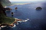
Kalaupapa peninsula seen from the east, with the rocky islands of Huelo, Okala and Mōkapu

Oblique aerial view of the Kalaupapa Peninsula


Individual evidence
- ↑ city-data.com: Kalaupa Ahupuaʻa, etc.
- ↑ city-data.com: Waikolu Ahupuaʻa
- ↑ Mark D. McCoy: The Lands of the Hina: An Archeological Overview and Assessment of Kalaupapa National Historical Park, Molokaʻi, Chapter 8: Assessment ( Memento of the original from September 1, 2011 in the Internet Archive ) Info: The archive link was automatically inserted and not yet checked. Please check the original and archive link according to the instructions and then remove this notice. (PDF; 1.5 MB), page 33
- ↑ SkyscraperCity: Kalawao County, Hawaii: Pop. 120 and falling
- ^ Burea of the Census: HAWAII. Population of Counties by Decennial Census: 1900 to 1990
- ↑ National Park Service: Kalaupapa National Historical Park, Hawaiʻi
- ↑ Best practices and specific structure for the cultural management of natural resources in Hawai ( Memento of the original dated November 14, 2007 in the Internet Archive ) Info: The archive link was inserted automatically and has not yet been checked. Please check the original and archive link according to the instructions and then remove this notice.
Web links
- Hawaii 4 (or 5) Counties (English)
- Kalawao County Official Census Map (PDF; 240 kB)
- Kalawao County Census Map (PDF; 229 kB)
- Kalaupapa Census Block Map (PDF; 86 kB)
- Kalawao County, HI Business Directory
Coordinates: 21 ° 12 ′ N , 156 ° 58 ′ W