Gregory Lake
| Gregory Lake | ||
|---|---|---|

|
||
| Geographical location | Central Sri Lanka | |
| Drain | Thalagala Oya | |
| Data | ||
| Coordinates | 6 ° 57 '24 " N , 80 ° 46' 26" E | |
|
|
||
| Altitude above sea level | 1877 m | |
| surface | 30 ha | |
| length | 1.2 km | |
| width | 600 m | |
| PH value | 7.8 | |
|
particularities |
Reservoir |
|
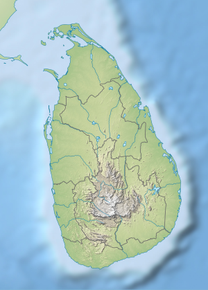
The Gregory Lake is a reservoir in the town of Nuwara Eliya in central Sri Lanka .
geography
It has a length of about 1.2 km and measures at its widest point about 600 m with an extension of 30 hectares. The Thalagala Oya, a tributary of the Nanu Oya, is dammed in it in the upper catchment area of the Mahaweli .
Naming
The lake was laid out in 1873 by then British Governor Sir William Henry Gregory and for a long time served as the basis of a hydroelectric power plant.
Pollution and usage
Despite its proximity to the source, the water is badly affected by agriculture and tourism and tends to eutrophicate (... the lake is in a persistent meso to eutrophic state). Its cadmium content of 13.6 µg / l also makes it only conditionally useful for the production of drinking water. Today the lake is used exclusively for local recreation.
Individual evidence
- ↑ Lake Gregory, Alien Flora and Urban Aqua-Environments in a misty City of Sri Lanka (PDF; 294 kB)
- ↑ Pollution of River Mahaweli and farmlands under irrigation by cadmium from agricultural inputs leading to a chronic renal failure epidemic among farmers in NCP, Sri Lanka ( page no longer available , search in web archives ) Info: The link was automatically marked as defective. Please check the link according to the instructions and then remove this notice. (PDF; 914 kB)

