Gungywamp
Coordinates: 41 ° 23 '24 " N , 72 ° 3' 36" W.
Gungywamp is a 4 acre archaeological site located approximately 2 km from Groton , Connecticut, USA . On the one hand, artifacts of the Indians living there were found there from the period between 2000 and 770 BC. On the other hand, there were remnants of the colonial era.
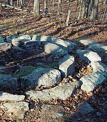
To the north of two stone chambers there is a stone circle of 21 stones, arranged in two concentric circles, with a total diameter of more than three meters. The lying stones were interpreted as a tan mill , with the help of which tannin was extracted for leather processing or parchment was produced. This Vogt Indian Ledge Shelter Site was excavated in the 1980s and early 90s to a depth of 95 cm where the bedrock was encountered. David Barron, 1979 founder of the Gungywamp Society , directed the excavations, consulting with Connecticut State Archaeologist Dr. Nicholas Bellantoni advised.
At a depth of 25 cm, clay artifacts from the late woodland phase from the period between 1200 and 1600 were found. These included arrowheads, so-called Susquehanna Points, from the period between 1500 and 500 BC. BC, with some organic remains dating back to around 770 BC. Could be dated. No datable remains could be found at the level of the rock floor, so that it is not clear how old the broken blade fragments and broken stones that were found there are, which were apparently exposed to great heat of fire. They possibly go back to around 2000 BC. Chr. Or further back.
In a basement room, the "Calendar" Chamber , the equinox could be read, because at that time a niche in the wall was reached by sunlight through a hole in the west wall. A little further away was a series of upright stones that extended north-south. One of them had a carved image of a bird with its wings outstretched. One of the big stones is the so-called Echo Rock , which glaciers brought here during the last ice age.
In addition, numerous arrowheads, tees and pottery shards were found. Pottery, buttons, coins, bottles and window glass, pipes, bricks and animal bones, especially from sheep, were also found from the colonial era. Few artefacts were found in the small houses made of reading stones that were built in the early colonial days. A “maid” Johanna Adams lived in her father's house. A coin from 1742 with the inscription "GEORGIUS" was found near the hearth. The “U” in the name of the king indicated that it was an American coinage, as the “V” was preferred in England. A small chamber is now interpreted as an ice house, which was used to store the coolant in the warm season.
In the north complex there was a rectangular ledge in which archaeologists found tree trunks on three sides, which indicated an indigenous building made from young trunks. Two hearths corroborated this assumption. Nearby was an elongated barrow that was wide in the middle and narrow at the tips. There were three towering stones on the grave. A total of 19 of these graves were discovered in the vicinity, others were on rocks scattered in the area. There are also three individual menhir-like stones.
In the 17th century, the area apparently belonged to the sons of Governor John Winthrop and a family, Christopher, who mined iron here. In the early 20th century, some Narragansett or Pequot settled on the site.
The historical imagination particularly stimulated the sunken chambers, which were believed to have come from Irish monks.
In 1979 the Gungywamp Society was founded. The Denison Pequotsepos Nature Center grants access to the site .
Web links
- Gungywamp, A Virtual Tour , Denison Pequotsepos Nature Center website
- The Gungywamp: An Overview ( Memento from June 28, 2010 in the Internet Archive ), Version v. June 28, 2010
Remarks
- ↑ This and the following according to Gungywamp Society ( Memento from June 28, 2010 in the Internet Archive )
- ↑ David P. Barron, Sharon Mason, “The Greater Gungywamp,” North Groton, CT, A Guidebook , 1994 revised edition.

