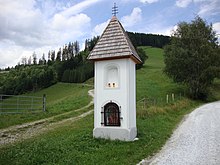
Gurzgruber Cross
The Gurzgruber Cross , also written Gurzgruber Cross , is a listed wayside shrine in the municipality of Kainach near Voitsberg in western Styria .
Location
The wayside shrine is in the village of Hadergasse, not far from the border between the two communities Kainach bei Voitsberg and Geistthal-Södingberg , near the road connecting Geistthal and Gallmannsegg through the Almgraben . A little west of the wayside shrine is the address Hadergasse 22 belonging to Kainach bei Voitsberg and a little east the address Kleinalpe 35 belonging to Geistthal-Södingberg.
history
The Gurzgruber Cross was erected around 1900 as a signpost for the pilgrims on the way from Maria Lankowitz to Sankt Pankrazen .
description
The Gurzgruber Cross is a pillar shrine with a total height of 3.0 meters, a width of 1.4 meters and a depth of 1.1 meters. It has a rectangular plan. The wayside shrine is plastered with white marble sand and white cement . At the front there is the 0.9 meter high, arched main niche directly above the base. In the upper half of the wayside shrine is the upper niche, which is somewhat narrower and shallower than the main niche. The other three sides of the wayside shrine are plain and not articulated. The pyramidal roof with wooden shingles covered and carrying at the top a wrought iron Three bars cross.
The main niche can be closed with a small wood-framed glass door and a wrought-iron bar grille in front of it. It houses a 15 centimeter high statue made of porcelain , which is framed on both sides by a pressed glass vase with a bouquet made of paper mache . The upper niche was originally provided with paintings, which have not been preserved.
literature
- Irmgard Dietl: The upper Kainachtal. From the history of the communities of Kainach, Gallmannsegg and Kohlschwarz . Kainach municipality, Gallmannsegg municipality, Kohlschwarz municipality, Kainach / Gallmannsegg / Kohlschwarz 2006, p. 342 .
Individual evidence
- ↑ Federal Monuments Office : Styria - immovable and archaeological monuments under monument protection. (PDF) In: www.bda.gv.at. Retrieved September 26, 2019 .
- ↑ a b c d Irmgard Dietl: The upper Kainachtal. From the history of the communities of Kainach, Gallmannsegg and Kohlschwarz . Kainach municipality, Gallmannsegg municipality, Kohlschwarz municipality, Kainach / Gallmannsegg / Kohlschwarz 2006, p. 342 .
- ^ A b Walter Brunner (Ed.): History and topography of the Voitsberg district . tape 2 . Steiermärkisches Landesarchiv, Graz 2011, p. 51 .
Coordinates: 47 ° 11 '22.8 " N , 15 ° 7' 22.3" E
