Gustav Haestskau
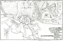
Gustav Haestskau worked as a surveyor in Prussia in the early 18th century . In the city of Spandau from 1724 to 1728, on behalf of the Prussian-Kurmärkischen War and Domain Chamber, he created an eight-part cadastral work of the then independent city of Spandau and the surrounding lands. For the first time, a complete real estate cadastre was created for the fortified city of Spandau with the large-scale maps Spandau Intra moenia (1: 1,000) and Spandau extra moenia (1: 3,100) as well as the corresponding owner registers, which are still available today. What is remarkable is the precision of the boundary representations in the maps, which can be brought into cover with today's cadastral maps.
Haestskau, who had been active in Spandau since 1720, married again after the death of his wife in 1728 in the Nikolaikirche in Spandau; He is said to have left Spandau in 1730. Little is known about his origins, training and further life after his work in Spandau. He worked for Joachimsthal and Golzow around 1735 and is said to have worked in the Magdeburg area afterwards .
His professional position in the city of Spandau cannot be clarified beyond doubt. He worked as a conductor on behalf of the Prussian state; the city of Spandau only had to pay for his salary. Since he was referred to as a royal surveyor, it can be assumed that he was a civil servant. However, he could also have acted as a loan recipient, ie as an appointed, freelance surveyor, similar to a present-day publicly appointed surveyor . During his time in Spandau, Haestskau was also busy with smaller surveying matters, e.g. B. with the production of a building template, a border regulation or with the measurement and the tower height determination of the St. Nikolaikirche.
According to him, since 15 June 2000 in a Geodätenviertel at the congress INTERGEO of the 2000 German Association of Surveying and the German Association of Cartography in Berlin Gustav-Haestskau Street in the district of Spandau (settlement Havelblick, Gatow ) named.
Individual evidence
- ↑ Reprints: Vermessungsamt Berlin-Spandau, Original: Signatures XI. HA, E 1238 and XI. HA, B 688 Secret State Archives Prussian Cultural Heritage
- ↑ Joachim Pohl: The citizen and residents cadastre of the city of Spandau from 1723. (Series of publications of the Stoye Foundation, Volume 23). Degener & Co., Neustadt an der Aisch 1993, ISBN 3-7686-4134-7 , p. 19.
- ↑ cartography interest fields in Joachimsthal, 1: 5000 , Prussian Privy State Archives
- ↑ Map series Zinsbare Heideäcker between the Schlopfbruchten and the Bugsin-See, 1: 5,000 , Secret State Archives Prussian Cultural Heritage
| personal data | |
|---|---|
| SURNAME | Haestskau, Gustav |
| BRIEF DESCRIPTION | German land surveyor |
| DATE OF BIRTH | before 1720 |
| DATE OF DEATH | after 1735 |

