Höhne (Wuppertal)
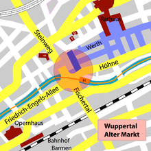
The Höhne is a main road in Wuppertal and a 0.8 kilometer long section of the federal highway 7 (B 7). In the Barmen district ( Barmen district) it runs from the west, where it begins at the Alter Markt intersection . It continues the B 7 from Friedrich-Engels-Allee , to the north the Steinweg goes at the Alter Markt and to the south the street Fischertal . It ends in the east and becomes Berliner Strasse . From the beginning to the end at the Werther Bridge , it runs parallel to the Wupper .
history
The street was renamed in its current name in 1935 by merging the streets Karlstraße , Neustadtstraße and Höhnestraße . The Höhnestraße was also called Höhnenstraße at times and before that, In the Heights . The Karstraße was to earlier times Carlstraße written. The origin of the name Höhne is derived from Höhe , a path that was slightly higher than the Wupperaue.
The Höhnestrasse and Karstrasse emerged from the older paths. In 1738 the route that goes up from the Wupper to the Märkische is indicated on a map as the Fuhrweg.
The expansion and straightening of the B 7 and thus the Höhne took place in 1952. Before that, numerous half-timbered houses covered with slate in the densely built, winding street were destroyed in the air raid on Barmen in 1943.
Buildings
In the so-called Lichtburg (Höhne 2 and 4), which used to be a cinema and is now part of a branch of a fast-food restaurant, the Pina Bausch dance theater has its rehearsal rooms.
literature
- Wolfgang Stock: Wuppertal street names . Thales Verlag, Essen-Werden 2002, ISBN 3-88908-481-8
Web links
Coordinates: 51 ° 16'15 " N , 7 ° 12'8.4" E

