Hanko Peninsula
| Hanko Peninsula | ||
| Geographical location | ||
|
|
||
| Coordinates | 59 ° 50 ′ N , 23 ° 5 ′ E | |
| Waters 1 | Baltic Sea | |
| length | 30 km | |
| width | 10 km | |
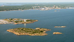
 Hanko in the south of the peninsula |
||
The Hanko Peninsula ( Finnish : Hankoniemi ; Swedish : Hangö udd ) is an approximately 30 km long and 10 km wide headland in the south of Finland . In the extreme south of the peninsula is the city of Hanko and the southernmost point of mainland Finland.
Flora and fauna
The peninsula, which is only sparsely covered with bushes and low trees, is known for its long sandy beaches and islets. A number of animal species are native to the deciduous and coniferous forests on the Hanko Peninsula. Moose , foxes , martens , tits , deer and woodpeckers can be found here .
history
The naval battle of Hanko took place near the island in 1714 and ended in a heavy defeat for the Swedish fleet .
In April 1918, as part of the Finland intervention, German troops from the Baltic Sea Division landed on the peninsula to support the Finnish government in the Finnish civil war .
After Finland's defeat in the Winter War , the southern part of the island was leased to the Soviet Union as a naval base in the course of the Peace of Moscow . In 1941, after the withdrawal of 25,000 Soviet soldiers in the Continuation War , the base was taken by the Finnish army .
Remains of the military installations built over the centuries in the south of the island can still be seen today.
