Hann glacier
| Hann glacier | ||
|---|---|---|
|
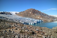
Hanngletscher (August 2016) |
||
| location | Southeast Greenland | |
| Type | Outlet / sea glacier | |
| Exposure | Northeast | |
| Coordinates | 65 ° 52 ′ N , 38 ° 21 ′ W | |
|
|
||
| drainage | Johan Petersen's Fjord, Sermilik , Irmingersee | |
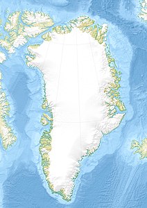
The Hanngletscher (also Harngletscher ) is a small sea glacier in southeastern Greenland about 75 kilometers south of the Arctic Circle . It forms an outlet of the Greenland Ice Sheet and is located 26 kilometers west of Tiniteqilaaq and 43 kilometers northwest of Tasiilaq . The glacier flows in a north-easterly direction and calves into the Qeertartivatsaap Kangertiva (Johan Petersen's Fjord), a tributary of the Sermilik, after an altitude difference of around 1000 meters . To the south of the glacier lies a prominent peak, at 1238 meters the highest point near the coast in the vicinity. Immikeertikajik Island is 1,300 meters north of the calving front.
Due to its location in the southern part of the Sermilik, which is largely ice-free in the summer months, the Hann Glacier is often visited on boat tours. With a little luck you can watch the glacier calving from a boat .
Web links
Individual evidence
- ^ Arctic Sun Maps (2015): Kort over (Map of) Tasiilaq / Kulusuk . Scale 1: 250,000. ISBN 978-87-992925-7-8 .


