Tochni
|
Tochni Τόχνη Tochni |
||
|---|---|---|
|
|
||
| Basic data | ||
| State : |
|
|
| District : | Larnaka | |
| Geographic coordinates : | 34 ° 47 ′ N , 33 ° 19 ′ E | |
| Residents : | 424 (2011) | |
| LAU-1 code no .: | CY-03 | |
| Postal code : | 7740 | |
| Telephone code : | +357 (90) | |
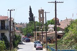
| A street in Tochni | ||
Tochni (sometimes Tokhni , Greek Τόχνη , Turkish Tochni ) is a place in the district of Larnaka , Republic of Cyprus . In 2011 it had 424 inhabitants.
location
The place is on the south side of Cyprus , about halfway between Larnaka and Limassol . It is not far north of Autobahn 1 . The next places are Chirokitia and Kalavasos .
history
Before the August 1974 massacre , Tochni had an equal share of Turkish and Greek Cypriot populations. On the night of August 14-15 , 1974, EOKA-B , a Greek Cypriot paramilitary militia , kidnapped and killed 85 Turkish Cypriot men.
Attractions
In the center of Tochni you can visit the ruins of a Latin church . From there you can see the Orthodox Church of Saints Constantine and Helena. The mosque , the madrasa and the Islamic cemetery are located in the eastern district. In order to preserve the regional tradition, the typical stone houses still stand in Tochni, which are gradually being restored. The stones for this are quarried in a nearby quarry .
Web links
Individual evidence
- ↑ Tochni and Kalavasos. Retrieved March 25, 2017 .
- ^ Paul Sant Cassia, Bodies of Evidence: Burial, Memory, and the Recovery of Missing Persons in Cyprus , Berghahn Books, 2007, ISBN 978-1-84545-228-5 , p. 61.


