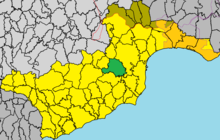
Kalo Chorio (Larnaca District)
|
Kalo Chorio Καλό Χωριό Vuda |
||
|---|---|---|
|
|
||
| Basic data | ||
| State : |
|
|
| District : | Larnaka | |
| Geographic coordinates : | 34 ° 56 ' N , 33 ° 32' E | |
| Height above d. M .: |
86 m |
|
| Surface: | 27.3504 km² | |
| Residents : | 1518 (2011) | |
| LAU-1 code no .: | CY-03 | |
| Website: | www.kalochoriolarnacas.org/en | |
Kalo Chorio ( Greek Καλό Χωριό , Turkish Vuda ) is a place in the Larnaka district in Cyprus . At the last official census in 2011, the place had 1518 inhabitants.
location
Kalo Chorio is located in the southeast of the island of Cyprus at an altitude of 86 meters, about 30 km southeast of the capital Nicosia , 6 km west of Larnaka and 51 km northeast of Limassol .
The place is about 9 km from the Mediterranean Sea in the coastal hinterland of Larnaka Bay . The foothills of the Troodos Mountains begin further to the west and the buffer zone to the northern part of the island begins a few kilometers to the north . The Autobahn 5 and the B5 run to the very south of the municipality and the A3 to the east .
Places in the vicinity are Goşşi in the north, Aradippou and the city of Larnaka in the east, Dromolaxia and Tersefanou in the south, Klavdia in the southwest, Pyrga in the west and Agia Anna and Psevdas in the northwest.
Population development
| year | 1881 | 1891 | 1901 | 1911 | 1921 | 1931 | 1946 | 1960 | 1973 | 1976 | 1982 | 2001 | 2011 |
| Residents | 422 | 413 | 459 | 533 | 567 | 652 | 660 | 562 | 735 | 687 | 1417 | 1334 | 1518 |
| Source: 1881-2001, 2011 | |||||||||||||
Web links
- The community site (English)
Individual evidence
- ↑ a b Statistical Service. cystat.gov.cy, accessed March 24, 2019 . (Download)
- ↑ akalochoriolarnacas.org : History . Accessed March 27, 2019

