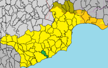
Alaminos (Cyprus)
|
Alaminos Αλαμινός |
||
|---|---|---|
|
|
||
| Basic data | ||
| State : |
|
|
| District : | Larnaka | |
| Geographic coordinates : | 34 ° 48 ' N , 33 ° 26' E | |
| Height above d. M .: |
66 m |
|
| Residents : | 345 (2011) | |
| LAU-1 code no .: | CY-03 | |
| Website: | alaminos.org | |
Alaminos ( Greek Αλαμινός ) is a place in the Larnaka district in Cyprus . In 2011 the place had 345 inhabitants. Until 1960 about half of the population consisted of Cypriot Turks and Cypriot Greeks .
geography
Alaminos is located in the south of the island of Cyprus at an altitude of 66 meters, a few kilometers from the Mediterranean Sea. It is located about 42 km south of the capital Nicosia , 21 km southwest of Larnaka and 39 km east of Limassol . The Autobahn 5 and the B5 run north of the municipality .
The surrounding landscape is dominated by olive and pine trees , mainly fruits and vegetables are grown. The place itself consists mostly of traditional Cypriot buildings. Although the place is away from the coast, the municipality extends to the sea, which is why Alaminos has a small port.
Places in the area are Kofinou and Menogeia in the north, Anafotia and Mazotos in the east and Agios Theodoros in the west.
Web links
Individual evidence
- ↑ Statistical Service (download, accessed February 23, 2019)
- ↑ a b alaminos.org: History (English, accessed on February 23, 2019)

