Oroklini
|
Oroklini Ορόκλινη |
||
|---|---|---|
|
|
||
| Basic data | ||
| State : |
|
|
| District : | Larnaka | |
| Geographic coordinates : | 34 ° 59 ′ N , 33 ° 39 ′ E | |
| Height above d. M .: |
50 m |
|
| Surface: | 15.214 km² | |
| Residents : | 6134 (2011) | |
| LAU-1 code no .: | CY-03 | |
| Website: | www.voroklini.org | |
| The Oroklini Lake | ||
Oroklini or Voroklini ( Greek Ορόκλινη ) is a place in the Larnaka district in Cyprus . At the last official census in 2011, the place had 6134 inhabitants.
location
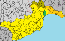
Oroklini is located in the southeast of the island of Cyprus at an altitude of 50 meters, about 33 km southeast of the capital Nicosia , 6 km northeast of Larnaka and 30 km west of Agia Napa .
The actual place is located about 1 km from the Mediterranean Sea on the Bay of Larnaka . It is on Highway 3 from Larnaca Airport to Agia Napa and on the B3 . In the north the municipality borders on the buffer zone with Northern Cyprus . To the south is Oroklini Lake , a Natura 2000 reserve.
Places in the area are Pyla in the northeast and behind it the British military base Dhekelia with the Cypriot exclaves Xylotymbou and Ormideia , Livadia and Larnaka in the southwest, Kellia in the west and Troulloi in the buffer zone in the northwest.
Web links
- The community site (English)
- Oroklini on the tourism side of the Larnaca region (English)
Individual evidence
- ^ Statistical Service. cystat.gov.cy, accessed March 24, 2019 . (Download)
- ↑ Voroklini (Oroklini) , Larnaka Tourism Board , accessed on March 31, 2019 (English)


