Harmil
| Harmil | ||
|---|---|---|
| Satellite photo of Harmil | ||
| Waters | Red Sea | |
| Archipelago | Dahlak Archipelago | |
| Geographical location | 16 ° 31 '23 " N , 40 ° 9' 25" E | |
|
|
||
| length | 6 km | |
| width | 5 km | |
| surface | 23.24 km² | |
| Highest elevation | 9 m | |
| Residents | uninhabited | |
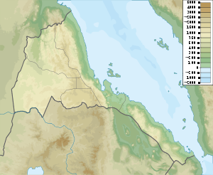
Harmil is the fifth largest island and one of the northernmost islands of the Dahlak archipelago , which belongs to Eritrea . The uninhabited island in the Red Sea is, like the entire archipelago, part of the administrative region of Semienawi Kayih Bahri .
The island only reaches a height of nine meters.
During the Second World War, the island, about 5 km wide and 6 km long, served as a gun emplacement for the Italians.
Individual evidence
- ↑ Topographic map of the General Staff of the USSR 1: 200,000, map sheet S37-35 ( GIF file ( page no longer available , search in web archives ) Info: The link was automatically marked as defective. Please check the link according to the instructions and then remove this notice . ) Russian
- ↑ http://fireonthewaters.tripod.com/BATTLE%20OF%20HARMIL%20ISLAND.pdf

