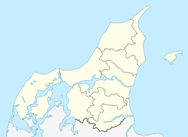
Hirtshals Fyr
| Hirtshals Fyr | ||
|---|---|---|
| View from the southwest | ||
| Place: |
|
|
| Location: | North Jutland , Denmark | |
| Geographical location: | 57 ° 35 '5 " N , 9 ° 56' 31.6" E | |
| Fire carrier height : | 35 | |
| Fire height : | 57 | |
|
|
||
| Identifier : | FFl.W.30s | |
| Scope knows: | 25 nm (46.3 km ) | |
| Optics: | Lightbulb with lens | |
| Operating mode: | electric | |
| Function: | Sea fire | |
| Construction time: | from 1859 | |
| Operating time: | since January 1, 1863 | |
| International ordinal number: | B2106 | |
With a fire height of 57 m, Hirtshals Fyr is one of the tallest lighthouses in Denmark and is located in Hirtshals in the north of Jutland . Project planning for the lighthouse began in February 1859, the foundation stone was laid on June 28, 1860. On January 1, 1863, Hirtshals Fyr went into operation. The tower was built of red brick with Dutch tiles on a concrete and granite foundation.
Day identifier
The daytime identifier of the lighthouse was originally gray and has been a slightly yellowish white since 1960.
sightseeing
From June to August there are guided tours on some Sundays. There is also a small exhibition in the lighthouse.
literature
- Ove Hermansen: Danmarks fyrtårne and fyrskibe. Billesø & Baltzer Verlag, ISBN 978-87-7842-286-6
Web links
Commons : Hirtshals Fyr - Collection of images, videos and audio files
- Dansk Fyrliste 2015. (PDF; 5.3 MB) Søfartsstyrelsen, accessed on January 15, 2018 (Danish).
- Panorama from the viewing gallery of the lighthouse on panorama-photo.net
Individual evidence
- ↑ Hirtshals Fyr History. (No longer available online.) Archived from the original on January 3, 2014 ; accessed on January 2, 2014 . Info: The archive link was inserted automatically and has not yet been checked. Please check the original and archive link according to the instructions and then remove this notice.
- ↑ a b website of Hirtshals Fyr. Retrieved January 2, 2014 (Danish).

