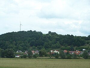
High Rod
| High Rod | ||
|---|---|---|
|
View of the Werra valley near Dippach |
||
| height | 322.6 m above sea level HN | |
| location | Thuringia ( Germany ) | |
| Coordinates | 50 ° 55 '27 " N , 10 ° 3' 27" E | |
|
|
||
| rock | Red sandstone | |
The Hohe Rod is a 322.6 m high elevation and marks the field boundary between Berka / Werra and Dippach in the town of Werra-Suhl-Tal in the Wartburg district in Thuringia . The pre-summit in Dippacher Flur bears the field name Wolfsberg.
In terms of nature, the Hohe Rod mountain is part of the Berka basin . It has been used in agriculture and forestry for centuries. In terms of settlement geography, the name Hohe Rod indicates a late clearing. The western slope, which descends steeply into the Werra Valley, offered several opportunities to build quarries. The sandstone quarries that are now neglected show exposed outcrops, some of which are 30 m thick.
An old road leads over the Hohe Rod mountain to Vacha and the southern part of the Berkaer Landwehr. An oak tree by the roadside marks the previously undated barrow of Beck's grave .
One of the first wind turbines in the Wartburg district is located on the summit.
Individual evidence
- ↑ Official topographic maps of Thuringia 1: 10,000. Wartburgkreis, district of Gotha, district-free city of Eisenach . In: Thuringian Land Survey Office (Hrsg.): CD-ROM series Top10 . CD 2. Erfurt 1999.
- ^ Geyer, Jahne, Storch: Geological sights of the Wartburg district and the independent city of Eisenach . In: District Office Wartburgkreis, Lower Nature Conservation Authority (Hrsg.): Nature conservation in the Wartburgkreis . Booklet 8. Printing and publishing house Frisch, Eisenach and Bad Salzungen 1999, ISBN 3-9806811-1-4 , p. 106-07 .
- ↑ ?? Wartburg district, south . In: Sven Ostritz (Hrsg.): Archaeological hiking guide Thuringia . No. 12. Beier & Beran, Weimar 2011, ISBN 978-3-941171-41-1 .


