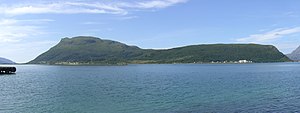
Hugla
| Hugla | |
|---|---|
| Waters | European Arctic Ocean |
| Geographical location | 66 ° 11 '12 " N , 12 ° 55' 10" E |
| surface | 17.9 km² |
| Highest elevation | Hugltinden 624 m |
| Residents | 105 5.9 inhabitants / km² |
Hugla is a Norwegian island that lies at the northern end of the mouth of the Ranfjord . The island belongs to the municipality of Nesna in the Norwegian Fylke Nordland .
The island name was already mentioned in the Snorra Edda and is related to the term haug , which is related to the German hill .
Most of the settlement is in the east of the island, which is connected to Nesna by a car ferry. The island has a school and a small shop.
Web links
Commons : Hugla - collection of images, videos and audio files
- Huglen web portal about the island (Norwegian)

