
Nesna
| coat of arms | map | ||
|---|---|---|---|

|
|
||
| Basic data | |||
| Commune number : | 1828 | ||
| Province (county) : | North country | ||
| Coordinates : | 66 ° 12 ' N , 13 ° 1' E | ||
| Surface: | 183.19 km² | ||
| Residents: | 1,761 (Feb 27, 2020) | ||
| Population density : | 10 inhabitants per km² | ||
| Language form : | Bokmål | ||
| Postal code : | 8700 | ||
| Website: | |||
| politics | |||
| Mayor : | Hanne Davidsen ( Ap ) (2015) | ||
| Location in the province of Nordland | |||

|
|||

Nesna is a Norwegian municipality in Fylke Nordland . The administrative seat of the municipality is the town of the same name, Nesna.
The municipality is located on the coast of the Helgeland region in the southern part of the Fylkes Nordland about 50 km west of Mo i Rana . Nesna consists of the outer part of a peninsula between the Ranfjord and the Sjona Fjord, the islands of Tomma (47 km²), Handnesøya (34 km²) and Hugla (18 km²) and a number of smaller islands.
The ferry from Nesna to Levang in the southern neighboring municipality of Leirfjord is part of the coastal road Fv17 . Nesna is also the landing stage for Hurtigruten ships .
coat of arms
Description : In blue a turned half golden point .
Personalities
- Ida Maria (* 1984), rock singer
photos

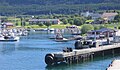
Nesna in February 2005 from a Hurtigruten ship
Nesna in June 2008 from a Hurtigruten ship


Web links
Individual evidence
- ↑ Statistisk sentralbyrå - Befolkning
- ↑ Store Norske Leksikon: Nesna - kommune i Nordland , accessed on September 24, 2010 (Norwegian)
Alstahaug | Andøy | Beiarn | Bindal | Bodø | Brønnøy | Bø | Dønna | Evenes | Fauske | Flakstad | Gildeskål | Grane | Hadsel | Hamarøy | Hattfjelldal | Hemnes | Herøy | Leirfjord | Lurøy | Lødingen | Meløy | Moskenes | Narvik | Nesna | Rana | Rødøy | Røst | Saltdal | Sortland | Rise | Sømna | Sørfold | Træna | Vefsn | Vega | Vestvågøy | Vevelstad | Vågan | Værøy | Øksnes