
Tomma
| Tomma | |
|---|---|
 |
|
| Waters | European Arctic Ocean |
| Geographical location | 66 ° 15 ′ N , 12 ° 49 ′ E |
 |
|
| length | 10.6 km |
| width | 8 kilometers |
| surface | 47.3 km² |
| Highest elevation | Tomskjevelen 922 m |
| Residents | 137 2.9 inhabitants / km² |
| main place | Husby |
Tomma is a Norwegian island in the municipality of Nesna in the province of Nordland . The name Tommas comes from the Old Norse ðǫmb ("from"). About 137 people live on the 137 km² island (as of 2001). Most live in the southern settlement of Husby . The highest mountain is Tomskjevelen in the northeast at 922 meters . Other elevations are the Breitinden (818 m), the Breitomma (803 m), the Rundtinden (643 m) and the characteristic Eidabelgen (217 m). There are burial mounds in several places- including the largest burial mound in the municipality of Nesna. The hill grave called Kvervan dates from the Merovingian period (600 to 800 BC), is two meters high and has a diameter of 20 meters. The main industries are agriculture and fishing. The island is connected to Nesna, the capital of the municipality of Nesna, by a car ferry.

Eidabelgen (217 m)
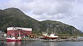
Harbor at the ferry terminal
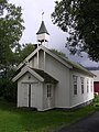
Husby Chapel

Tomskjevelen (922 m), the highest mountain on the island


Web links
Individual evidence
- ↑ a b Store Norske Leksikon: Tomma , accessed on September 24, 2010 (Norwegian)
- ↑ Nesnaferie.no: Kvervan, Tomma ( page no longer available , search in web archives ) Info: The link was automatically marked as defective. Please check the link according to the instructions and then remove this notice. , accessed September 24, 2010 (Norwegian)