Vestvågøy
| coat of arms | map | |
|---|---|---|

|
|
|
| Basic data | ||
| Commune number : | 1860 | |
| Province (county) : | North country | |
| Administrative headquarters: | Leknes | |
| Coordinates : | 68 ° 9 ' N , 13 ° 37' E | |
| Surface: | 424.56 km² | |
| Residents: | 11,433 (Feb 27, 2020) | |
| Population density : | 27 inhabitants per km² | |
| Language form : | neutral | |
| Postal code : | 8340-8373 | |
| Website: | ||
| politics | ||
| Mayor : | Remi Solberg ( Ap ) (2015) | |
| Location in the province of Nordland | ||

|
||
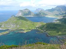
Vestvågøy is an island and at the same time a municipality in Fylke Nordland in the Lofoten region in Norway .
Location and dates
The Vestvågøy municipality has an area of 425 km² and 11,433 inhabitants (as of February 27, 2020). It is the most populous area of Lofoten and Vesterålen .
The main town and administrative center is Leknes with around 2700 inhabitants. Other larger settlements are the towns of Gravdal , Stamsund and Ballstad . The highest elevation in the area of the commune is the Himmeltindan ( 964 moh. ).
Transport links
Stamsund is the landing point for the daily Hurtigruten ships and there are daily scheduled connections to Bodø and Trondheim from Leknes Airport .
Since 2007 there has been a ferry-free connection to European route 6 and thus to the Norwegian mainland.
Districts
- Ballstad: an important fishing village in Lofoten
- Borg : with a Viking Museum, which was built on the excavation site of a Viking-era chief's court.
- Borge: a church with 700 seats, built in 1987
- Eggum: beautiful view of the surroundings
- Gravdal: Church worth seeing (Buksnes Kirke), built in 1905 in the "stave church style"
- Leknes: Center of the municipality with approx. 2,700 inhabitants
- Stamsund: landing stage of the Hurtigruten


