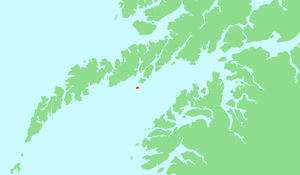
Skrova
| Skrova | |
|---|---|
| Waters | Vestfjord |
| archipelago | Lofoten |
| Geographical location | 68 ° 10 ′ N , 14 ° 41 ′ E |
| Number of islands | approx. 20 |
| Main island | Storskrova |
| Total land area | 4.5 km² |
| Residents | 237 |
Skrova is the name of a small group of islands and a fishing village in the municipality of Vågan in the Norwegian Fylke Nordland in Lofoten .
General
The northern branch of the Vestfjord between Svolvær and Skrova is also called Hølla . Skrova is the southernmost tip of a small island chain, consisting of Årsteinen , Stormolla and Litlmolla , which extends from northeast to southwest into the Vestfjord.
A plurality of warping and Holmen surrounds the two main islands Storskrova and Heimskrova , many of which by bridges and moles are connected. The Skrovafjell is located at the mountain Storskrova, which offers a fantastic panoramic view of the archipelago, the Norwegian mainland and the westward Lofoten. In Norway, Skrova is the combination of Lofot fishing and whaling of days gone by.
climate
| Skrova fyr 1961-1990 | ||||||||||||||||||||||||||||||||||||||||||||||||
|---|---|---|---|---|---|---|---|---|---|---|---|---|---|---|---|---|---|---|---|---|---|---|---|---|---|---|---|---|---|---|---|---|---|---|---|---|---|---|---|---|---|---|---|---|---|---|---|---|
| Climate diagram | ||||||||||||||||||||||||||||||||||||||||||||||||
| ||||||||||||||||||||||||||||||||||||||||||||||||
|
Average monthly temperatures and rainfall for Skrova fyr 1961–1990
|
||||||||||||||||||||||||||||||||||||||||||||||||||||||||||||||||||||||||||||||||||||||||||||||||||||||||||||||||||||||||
The fishing village
For the past two hundred years, Skrova has been the center of Lofoth high seas fishing and whaling in Northern Norway. Many an old fisherman longingly looks back on the old days when up to a thousand fishermen from the mainland wintered on the island. They were housed in the rorbu , where their boats were moored. At that time cod and saithe were caught seasonally in the winter months up to Easter. Stockfish was an export hit in the region. Nowadays the fishing industry consists of the offshore rearing tank for salmon and rainbow trout .

