
Stormolla
| Stormolla | |
|---|---|
| Waters | Vestfjord |
| Archipelago | Lofoten |
| Geographical location | 68 ° 15 '44 " N , 14 ° 52' 42" E |
 |
|
| length | 9 km |
| width | 4 km |
| surface | 34.4 km² |
| Highest elevation | Heggedalstind 751 moh. |
| Residents | 40 1.2 inhabitants / km² |
| main place | Brettesnes |
Stormolla is an island of Lofoten the municipality Vågan in Norwegian Fylke Nordland . The island is wedged between Austvågøya in the west and Hinnøya and Årsteinen in the east . The Vestfjordsunde Øyhellesundet and Raftsundet separate it from the rest of Lofoten. In the south is her now uninhabited smaller sister, Lille Molla .
General
Their main towns are Brettesnes on the southern tip and Ulvåg in the east, as well as Gullvika, Finnvik and Krabbvågen. Many summer houses typical of the Scandinavians can be found here. There was still a sardine factory in Finnvik until 1990 , but the inhabitants have either remained fishermen or have adapted to tourism, in the form of boat or hut rentals and fishing trips.
The Hurtigruten ships pass the island several times a day on their way through the Raftsundet from Svolvær to Harstad , making Stormolla a popular photo opportunity.
photos

Hermann Eschke - View from Svolvaer to Stormolla and Litlmolla
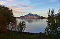
Stormolla from Raftsund


Individual evidence
- ↑ Stormolla , Norwegian Mapping Authority , Faktaark, accessed on 9 February 2017
Web links

Årsteinen | Austvågøya | Flakstadøy | Gimsøy | Hinnøya | Litlmolla | Mosques | Moskenesøy | Røst | Skrova | Stormolla | Værøy | Vestvågøy