
Austvågøya
| Austvågøya | |
|---|---|
 |
|
| Waters | European Arctic Ocean |
| Archipelago | Lofoten and Vesterålen |
| Geographical location | 68 ° 20 ' N , 14 ° 36' E |
 |
|
| length | 40 km |
| width | 30 km |
| surface | 526.7 km² |
| Highest elevation | Higravstinden 1146 m |
| Residents | 4177 7.9 inhabitants / km² |
| main place | Svolvær |
Austvågøya is also the largest and most easterly island in the Lofoten chain . It is divided into two municipalities. The north-eastern part is administered by the municipality of Hadsel located in the Vesterålen region , while the western and larger part forms the municipality of Vågan .
Austvågøya is also the only town in the island chain, Svolvær . In the southeast by the Vestfjord lies the idyllic and ancient fishing village of Kabelvåg with the Lofoten Museum . Another well-known fishing village is Henningsvær in the southwest. The European route 10 extends through the middle of the island from east to west, which is separated from the neighboring island of Hinnøya in the east by the Raftsund with the famous Trollfjord . The western Gimsøystraumen is the sound that separates the island from Gimsøy and thus from the rest of the archipelago. Both Sunde have been crossed by bridges since the 1990s.
geography
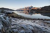
On Austvågøya are the three highest mountain peaks in Lofoten: Higravstinden (1146 m), Svartsundtindan (1050 m) and Trolltindan (1045 m). Vågakallen (942 m), near the fishing village of Henningsvær built on the archipelago , is a landmark and is the most climbed and most famous mountain in Lofoten.

Henningsvær fishing village

The Trollfjord with Trolltindan.
Raftsund with Trolltindan


history
The three islands Vestvågøy , Gimsøy and Austvågøya, together with Sørvågen on Moskenesøy, form the medieval cultural landscape of Vågan, i.e. the only places in Lofoten where agriculture alongside fishing has been possible since the Viking Age.
Famous pepole
- Gunnar Berg (1863–1893), painter, born in Svolvær
- Kari Bremnes (* 1956 in Svolvær), songwriter
- Hans Egede (1686–1758), pastor a. a. in Lofoten
Web links
- Info Svolvær
- Lofoten Aquarium
- Galleri lille Kabelvåg art gallery, Norwegian / partly English
- Lofoteninfo, German

Årsteinen | Austvågøya | Flakstadøy | Gimsøy | Hinnøya | Litlmolla | Mosques | Moskenesøy | Røst | Skrova | Stormolla | Værøy | Vestvågøy
